Basic Wave Patterns
The following are examples of some basic wave patterns often seen in upper level charts. These patterns can occur just about anywhere in the world outside of the tropics. The images also show the typical locations of weather associated with the basic patterns.
Open Waves
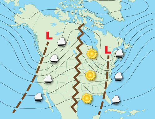
Whether longwave or shortwave, by far the most common pattern seen in upper air charts are just plain troughs and ridges. These waves and troughs are considered ‘open’ as, for the most part, there is no closed circulation associated with the waves.
They are progressive meaning they move from west to east. Low-pressure troughs are identified by brown dashed lines while ridges of high pressure are identified by brown zigzag lines.
The majority of inclement weather occurs between the trough and the downwind (eastward) ridge while fair weather occurs between the ridge and the downwind trough.
Positive Tilted Troughs
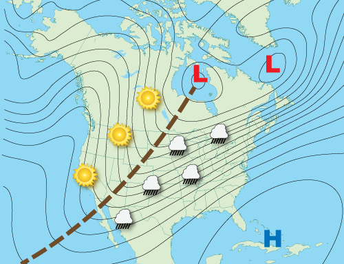
A trough’s axis is usually not directly in line from north to south but have some tilt relative to the poles.
Positive tilted troughs will extend from the lowest pressure northeast to southwest in the Northern Hemisphere (southeast to northwest in the Southern Hemisphere).
In respect to severe weather, positive tilted troughs produce the least amount.
Negative Tilted Troughs
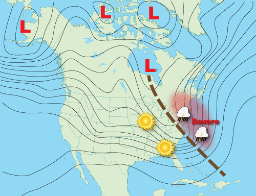
Negative tilted troughs usually begin as positive tilted troughs. As the short-wave energy races east though the longwave it distorts its shape from positive to neutral (north-south) orientation to a negative (northwest to southeast) orientation.
These types of troughs produce the most severe weather. This is because there is strong southerly surface wind with its warm air underneath the incoming cold air in the upper atmosphere creating unstable conditions.
Also, there is a large change in wind direction from the surface into the upper atmosphere (called wind shear) which aids in the formation of supercell thunderstorms. In this example, the New England states would be under a threat of severe weather.
Zonal Flow
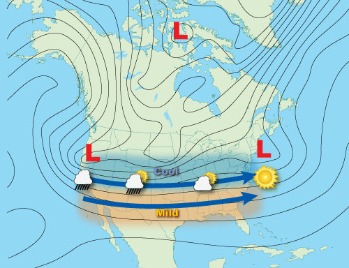
When the air flow is parallel (or nearly parallel) to the latitude lines then it is considered to be a zonal flow. Surface level storm systems, and associated cold fronts, move very fast from west to east in zonal flows but have very little north to south (or south to north) movement.
As a result, locations to the pole-ward of a zonal flow will remain cool or cold, while equator-ward, the weather remains mild or warm. Usually there is a positively and negatively tilted trough at each end of zonal flow.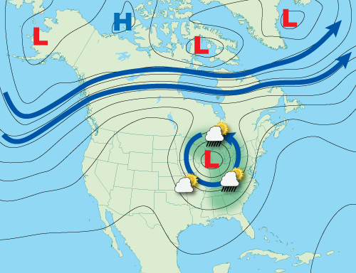
“Cut-off low, weatherman’s woe.” These are persistent low-pressure areas that have become isolated or ‘cut-off’ from the main airflow.
They usually result from a strong short wave moving south on the west side of troughs that extended the trough toward the equator. The momentum of the short wave pulls the trough out of the main airflow and forms a closed, low pressure, circulation.
The ‘woe’ comes for their agonizingly slow motion as they can drift for many days. While modern weather computer models forecast their drift rather well they still tend to forecast the closed low pressure to ‘open up’ and rejoin the main airflow aloft too quickly.
They can occur any time of the year and just about anywhere on the planet. Unsettled weather occurs over the eastern half of cut-off lows though there can be some precipitation wrapping around the north end of the low affecting the northwest quadrant.
Blocking Patterns
Blocking patterns occurs when centers of high pressure and/or low pressure set up over a region in such a way that they prevent other weather systems from moving through. When the blocking pattern is in place other systems are forced to go around it. Blocking patterns can remain in place for several days, resulting in long spans of persistent weather for locations under the block.
Blocking High
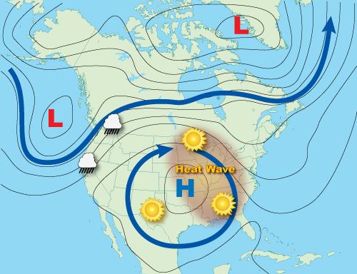
Typically, a summertime occurrence, blocking highs are responsible for major heat waves. Any precipitation is usually shunted around the periphery of the high-pressure area.
High pressure aloft causes the air to subside or sink. This downward motion compresses and warms the air in the lower atmosphere while simultaneously trapping heat rising from the earth’s surface, leading to heat waves.
The skies are usually clear due to the downward motion of air. Eventually blocking highs will weaken when a short wave moves over the top of the high causing it to decrease with an end to the heat wave.
Omega Block
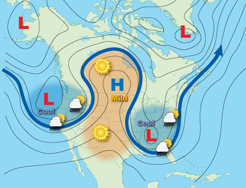
Omega blocks get their name because the upper air pattern looks like the Greek letter omega (Ω). Omega blocks are a combination of two cutoff lows with one blocking high sandwiched between them.
Because of their size, Omega blocks are often quite persistent and can lead to flooding and drought conditions depending upon one’s location under the pattern. Cooler temperatures and precipitation accompany the lows while warm and clear conditions prevail under the high.
Rex Block
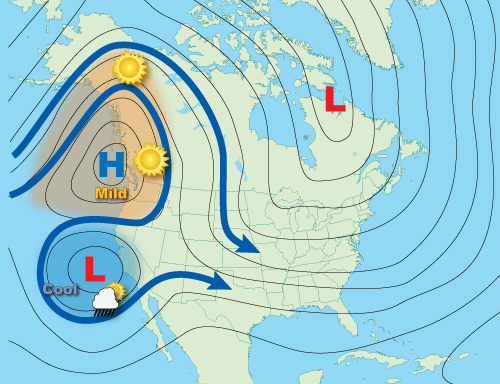
Rex blocks are characterized by a high-pressure system located pole-ward of a low-pressure system. The Rex block will remain nearly stationary until one of the height centers changes intensity, unbalancing the high-over-low pattern.
Unsettled, stormy weather is usually found near the low pressure while dry conditions are typical with the high-pressure. Strong, particularly persistent Rex blocks can cause flooding near the low-pressure part of the block and short-term drought under the high-pressure part.

 Amazon Best Sellers in Audible Books