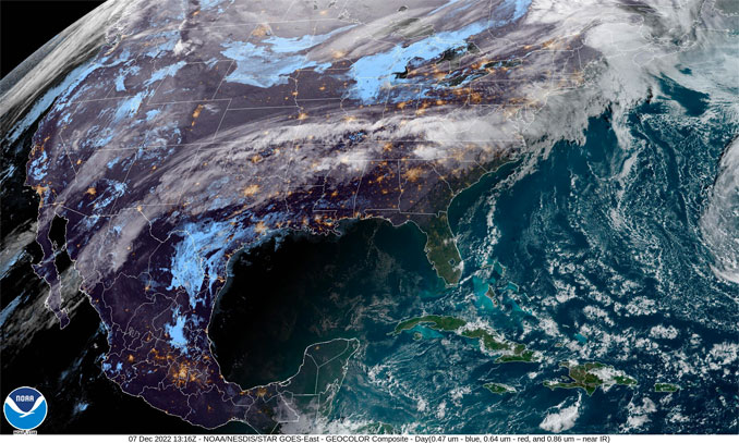
Heavy rain and flash flooding threat exists across the southern and central Plains later on Wednesday into Thursday.
Accumulating snows are forecast across the northern Plains today, then over parts of the central Rockies Wednesday night and early Thursday…
Next round of heavy precipitation expected to reach the Pacific Northwest by Thursday before spreading inland and down into California Thursday night into early Friday.
FAA National Airspace
A meandering front will continue to be the focus of active weather across the south-central portion of the mainland U.S. over the next couple of days. Fast upper-level southwesterly flow has already transported moisture all the way up the East Coast into New England early this morning with areas of moderate to locally heavy rainfall.
A jet stream arriving from the eastern Pacific will begin to interact with the trailing portion of the front across the southern Plains. This interaction will yield a more robust round of heavy rain from the southern Plains eastward across the mid-Mississippi Valley toward the Tennessee Valley Wednesday through Thursday morning. The latest WPC forecast calls for rainfall totals upwards of 2 inches over portions of the Ozarks through Thursday. This rainfall may lead to isolated instances of flash flooding over portions of eastern Oklahoma, Missouri, and Arkansas through Thursday morning. In addition, a low pressure system is forecast to form over the central High Plains today and begin to track eastward into the central Plains on Thursday. Temperatures will be cold enough to support snow across portions of the north-central Plains where a few inches of accumulation is forecast by Friday morning. In the shorter term, a swath of snow is forecast across the far northern Plains today behind an arctic front.
The overall pattern supporting the wet weather from the southern Plains into the Northeast will also support much above average temperatures over the next few days over the central to southern Plains, and eastward into the East Coast. An expansive area of record high minimum (and a few daily maximum) temperatures are forecast today and Thursday across portions of the southern Plains, lower Mississippi Valley, Tennessee Valley, Mid-Atlantic and Northeast.
By Thursday, the next Pacific system arriving along the West Coast will bring the next round of unsettled weather into the Pacific Northwest and then down into northern and central California by early on Friday. Heavy mountain snow can be expected to overspread first along the Cascades followed by the Sierra Nevada beginning later on Thursday. Periods of moderate to heavy rain can also be expected along the coastal sections. The snow will begin to penetrate further inland across the Intermountain region early Friday.
Kong/Asherman/NWS (slightly modified arrangement of text by CARDINAL NEWS)
+++++++++++++++++
CONUS = Continental United States
SOURCES:
Short Range Forecast Discussion NWS Weather Prediction Center College Park MD
SEARCH: NWS Weather Prediction Center College Park MD
NOAA/NWS Weather Prediction Center
Storm Prediction Center – www.spc.noaa.gov
AIR PRESSURE MAP SOURCE: Windy.com (air pressure)
Get updates from The Cardinal ALL NEWS FEEDS on Facebook. Just ‘LIKE’ the ‘Arlington Cardinal Page (become a fan of our page). The updates cover all posts and sub-category posts from The Cardinal — Arlingtoncardinal.com. You can also limit feeds to specific categories. See all of The Cardinal Facebook fan pages at Arlingtoncardinal.com/about/facebook …
Help fund The Cardinal Arlingtoncardinal.com/sponsor
Google Maps
The Maritimes — New Brunswick, Nova Scotia, and Prince Edward Island


