Signs of Tropical Storm Isaac’s arrival were already evident in New Orleans before it was a hurricane, with the wind picking up and people making preparations for rain and rising water.
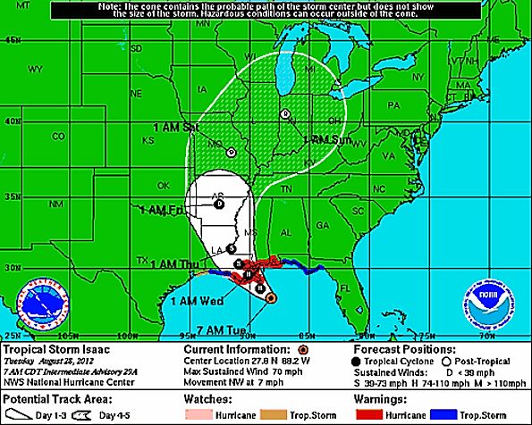
Hurricane status for Isaac at 12:20 p.m. EDT Tuesday August 28, 2012.
Location: 28.1°N 88.6°W, moving NW at 10 mph with a minimum pressure of 975 mb and maximum sustained winds of 75 mph.
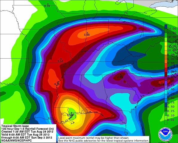
Tuesday morning, Tropical Storm Isaac had slowed down to a northwesterly speed of 7 mph. The slowing down emphasized the biggest danger, which is expected to be flooding caused by heavy rain. Up to 18-21 inches of rain are expected from about New Orleans to an area between Biloxi and Gulfport, Mississipi, and north just east of Bogalusa

120-hour rainfall forecast valid 8:00 a.m. EDT Tuesday, August 28, 2012.

Potential Storm Track of TS Isaac and Hurricane Isaac showing Isaac a hurricane in Louisiana and Mississippi on Tuesday and Wednesday, a tropical storm in Louisiana and Mississippi on Thursday, a tropical depression in Arkansas on Friday, and a post-tropical depression in Missouri, eastern Iowa, Illinois, southern Wisconsin, western Kentucky, western Tennessee, southern Michigan, and western Ohio from Saturday through Sunday.
Post-tropical storm remnants are expected to be showers and scattered shower Friday night through Sunday night in Chicagoland.
Friday Night A slight chance of showers. Partly cloudy, with a low around 70.
Saturday A chance of showers. Partly sunny, with a high near 83.
Saturday Night A chance of showers. Mostly cloudy, with a low around 69.
Sunday A chance of showers. Partly sunny, with a high near 83.
Sunday Night A slight chance of showers. Partly cloudy, with a low around 64.
Labor Day Mostly sunny, with a high near 83.
Become a fan of The Cardinal weather page. Submit your pictures or just stay up-to-date on weather topics — go direct to the Arlington Cardinal Weather photos. For a list of all of The Cardinal Facebook fan pages, go to Arlingtoncardinal.com/about/facebook …
