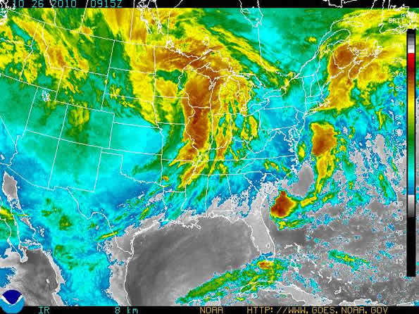
Satellite image on October 26, 2010 at 4:15 a.m. CDT.
UPDATE 7:12 AM: Tornado warning was canceled at 7:12 a.m. before it expiration of 7:30 a.m.
UPDATE 7:05: TORNADO WARNING for Kane County … TORNADO WARNING FOR…UNTIL 730 AM CDT * AT 654 AM…NATIONAL WEATHER SERVICE DOPPLER RADAR INDICATED A LINE OF SEVERE THUNDERSTORMS CAPABLE OF PRODUCING A TORNADO. THESE DANGEROUS STORMS WERE LOCATED NEAR ELBURN…AND MOVING NORTHEAST AT 50 MPH.* LOCATIONS IMPACTED INCLUDE…
GENEVA…ST. CHARLES…SLEEPY HOLLOW…ELGIN…CARPENTERSVILLE…
EAST DUNDEE…GILBERTS…WEST DUNDEE…PINGREE GROVE AND SOUTH
ELGIN.
UPDATE 7:00 AM: High winds associated with storm front, but lightning and rain is minimal. No hail, and no hail in the forecast. It appear likely that the main weather event will be the sustained winds and high gusts related to the low pressure, not the initial front. The radar image shows that more than half of the thunderstorm activity has passed, but a severe line trails at the end of the edge of the radar image.
UPDATE 5:30 AM: Tornado Watch issued at 3:30 a.m. October 26. 2010. Temperature rising slightly overnight from 69°F to 71°F. Dew points elevated at 60-61°F. Some wind gusts have already hit 50 mph in Peoria and Lombard. St. Louis experienced a gust to 62 mph.
UPDATE 5:00 AM: Barometric pressure reading at 4:52 a.m. CDT established new record of 29.07″ (984 Millibars).
——-
A very strong low pressure system or cyclone, which has already been named the “Great Lakes Cyclone” will develop across the central Plains today and tonight and rapidly strengthen as it moves from Kansas northeastward into northern Minnesota during the day Tuesday. Warm and breezy conditions prevailed Monday afternoon and are expected Monday evening, but more active weather arrives late tonight and Tuesday morning as winds increase ahead of a cold front that will cross the area.
First showers and thunderstorms are expected to arrive with the front between 4:00 a.m. and 9:00 a.m. Tuesday morning, which may also reach severe levels with damaging wind gusts. The thunderstorms are predicted to hit with gusts of their own, but then as the front passes, winds of the Great Lakes Cyclone are forecast to hit and sustain for up to 36 hours. Once the front passes, southwest winds will increase dramatically with sustained speeds between 30 and 40 mph. Gusts are expected in excess of 55 mph — most likely Tuesday afternoon. Wind gusts may decrease modestly Tuesday night, but winds will again pick up Wednesday with gusts in excess of 55 mph possible. The strongest winds are expected across northern Illinois and across Lake Michigan from about Joliet northward, or just north of Interstate 80 northward. Storm force winds (48 knots or greater) are expected on Lake Michigan with significant waves up to around 25 feet on the north half and around 20 feet on the south half, with occasional higher waves.
Winds south of Joliet are expected to be sustained at 25 to 35 mph with gusts to 40 to 50 mph.
How the upcoming cyclone ranks among other notable cyclones over the Great Lakes
INFORMATION FROM THE NATIONAL WEATHER SERVICE — ROMEOVILLE …
RANK EVENT DATE MINIMUM CENTRAL PRESSURE
1. Great Ohio Blizzard* Jan 26, 1978 950 HPA / 28.05 inches
2. Upcoming October event Oct 26-27, 2010 959 HPA / 28.35 inches **
3. Armistice Day Storm Nov 11, 1940 967 HPA / 28.55 inches
Anniversary Storm Nov 10, 1998 967 HPA / 28.55 inches
4. Cyclone of 1913
(aka White Hurricane) Nov 7-9, 1913 968 HPA / 28.60 inches
5. Edmund Fitzgerald Storm Nov 10, 1975 980 HPA / 28.95 inches
* In Chicago the storm was called the Blizzard of ’78 with Chicago snowfall of 58-60 inches.
** Average among several current forecast models.
The absolute low pressure of the Ohio Blizzard storm was picked up at Sarnia, Ontario at around the same time, where the barometer bottomed out at 28.21 inches of mercury (955 mbar).
The storm was also known as the Great Blizzard of 1978.
Pressures in the 960 millibars range are the levels seen in a Category 3 hurricane — although the winds are stronger in a Category 3 hurricane.
The 1996 Lake Huron cyclone (commonly known as Hurricane Huron, or the Hurroncane) was a strong cyclonic storm system that developed over Lake Huron in September 1996. It had some characteristics of a tropical cyclone.
Most intense minimum surface air pressure ever recorded was 870 mb (25.63 inHg); eye of Super Typhoon Tip over the Pacific Ocean, October 12, 1979.
The most intense in the Western Hemisphere was 882 mb (26.05 inHg) in the eye of Hurricane Wilma, October 19, 2005.
The most intense ever recorded on land: 892 mb (26.35 inHg); Craig Key, Florida, eye of the Labor Day Hurricane, September 2, 1935. While other landfalling tropical cyclones have almost certainly had lower pressures, data is spotty from areas other than the Atlantic basin, especially before the invention of weather satellites. It is possible that Typhoon Megi made landfall in Luzon with a lower central pressure.
Is this this the result of this upcoming Winter’s La Nina pattern?
Check Arlingtoncards.com/weather for latest forecast and warnings, conditions, radar images
,


 Amazon Best Sellers in Audible Books