


The National Weather Service Office Chicago forecasted thunderstorms in the area from before sunrise until mid-morning Friday, March 28, 2025, but it appears the main threat for the Arlington Heights area has passed. Scattered thunderstorms are forecast to move across the area through mid morning. The strongest storms will produce nickel size hail and heavy rain which may lead to ponding water in low lying and poor drainage areas. Storms may linger along the I-80 corridor through mid-afternoon.
Hail, smaller tan pea-size, fell in Arlington Heights just before 6:00 a.m.
No Severe Thunderstorm Warnings were issued in the Arlington Heights area early morning Friday.
Later on Friday the forecast is windy and warm. A combination of low relative humidity and southwest winds gusting to 40 mph will lead to an elevated fire danger this afternoon, mainly for areas south of Interstate 80. Winds will become southwesterly after sunrise (6:41 a.m. CDT) and steadily increase through the morning. Winds have been from the southeast overnight, 10 MPH or less.
Wind gusts are forecast to peak to 41 MPH from 4:00 p.m. to 5:00 p.m.
A cold front will move south into northern Illinois Saturday afternoon, turning temps much cooler, especially near Lake Michigan. After hitting a high of 67°F from 12 noon until 2:00 p.m., a cold front is forecast to pass through the area and drop the air temperature to 43°F by 8:00 p.m.
Scattered showers, possible thunderstorms Saturday/Saturday night, as the cold front lifts back north as a warm front.
Scattered thunderstorms Sunday afternoon. Some storms could be severe and produce damaging winds, especially toward central Illinois and central Indiana.
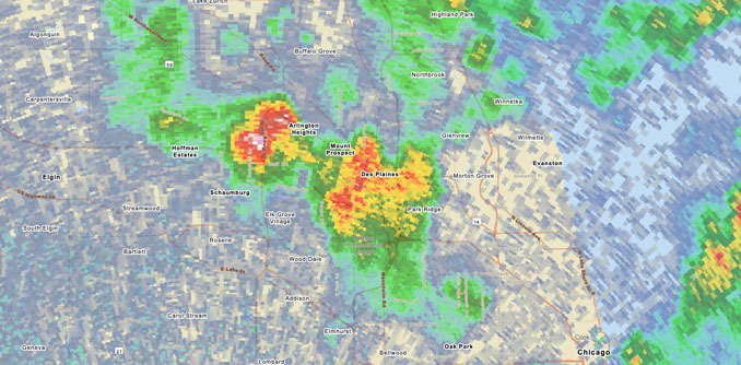
Weather Radarat 5:30 AM through 6 AM showed precipitation growing and diminishing, and moving toward the east or slightly toward the southeast. There were no additional thunderstorm cells west of the Arlington Heights area at 6:00 a.m., but there was a thin line of storms west of Rockford developing, with McHenry County and Lake County in its path. There was also a small, thin line of thundershowers indicated near Sterling, Illinois around 6:40 a.m.
See also Arlingtoncardinal.com/clouds
A special weather statement has been issued for Elgin IL, DeKalb IL and Carpentersville IL until 4:00 AM CDT pic.twitter.com/H6KBH7A4gr
— NWS Chicago (@NWSChicago) March 28, 2025
O’HARE FORECAST …
Overnight Thursday/Friday: Showers likely and possibly a thunderstorm. Cloudy, with a low around 49. South southeast wind around 10 mph. Chance of precipitation is 70%. New rainfall amounts of less than a tenth of an inch, except higher amounts possible in thunderstorms.
Friday: Showers and thunderstorms likely, mainly before 11am. Cloudy, then gradually becoming mostly sunny, with a high near 76. Breezy, with a southwest wind 10 to 15 mph increasing to 20 to 25 mph in the afternoon. Winds could gust as high as 40 mph. Chance of precipitation is 60%. New precipitation amounts between a tenth and quarter of an inch, except higher amounts possible in thunderstorms.
Friday Night: Mostly clear, with a low around 59. Breezy, with a southwest wind around 20 mph, with gusts as high as 40 mph.
Saturday: A 50 percent chance of showers, mainly after 1pm. Partly sunny, with a high near 67. Southwest wind around 15 mph, with gusts as high as 25 mph.
Saturday Night: A chance of showers, then showers likely and possibly a thunderstorm after 1am. Cloudy, with a low around 42. Northeast wind 10 to 15 mph becoming south southeast after midnight. Winds could gust as high as 20 mph. Chance of precipitation is 70%.
Sunday: Showers and possibly a thunderstorm. High near 67. Chance of precipitation is 90%.
Sunday Night: Rain showers likely before 4am, then rain likely, possibly mixed with snow showers. Mostly cloudy, with a low around 33. Chance of precipitation is 70%.
Monday: A chance of rain showers, mixing with snow after 7am, then gradually ending. Mostly cloudy, with a high near 41.
Monday Night: Partly cloudy, with a low around 30.
Tuesday: Mostly sunny, with a high near 44.
Tuesday Night: Showers likely. Mostly cloudy, with a low around 37.
Wednesday: Showers. Mostly cloudy, with a high near 57. Breezy.
Wednesday Night: A chance of showers. Mostly cloudy, with a low around 41.
Thursday: Partly sunny, with a high near 55.
SouthLakeMichiganDataPASTEHERE
march.chicagoweatherstation.com
Chicago Weather Forecast for your MAC/PC/TABLET includes surrounding suburbs.
^^ MOBILE? USE VOICE MIC ^^
facebook …
Please ‘LIKE’ the ‘Arlington Cardinal Page. See all of The Cardinal Facebook fan pages at Arlingtoncardinal.com/about/facebook …
Help fund The Cardinal Arlingtoncardinal.com/sponsor
 Amazon Best Sellers in Audible Books