

An area of light snow developed overnight dropping less than inch — as forecasted. Snow is expected to redevelop from the west and increase in intensity by mid-morning, with steady heavier snow developing across northern Illinois through midday and into northwest Indiana by afternoon. Highest snowfall rates in Chicagoland are expected to occur from west to east about 10 AM through 6 PM. The most intense snowfall in the Arlington Heights area is expected between 11 AM and 5 PM.
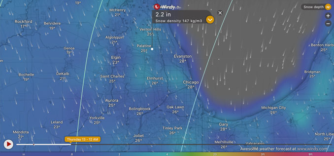
Here’s the Wednesday, February 12, 2025 (8:30 AM) snowfall outlook for Wednesday until midnight. The ECMWF model is indicating only about 2.2 inches total snowfall for Arlington Heights by Wednesday/Thursday at midnight. The GFS model is indicating about 4.7 inches total. The NWS Chicago graph forecast is indicating a snowfall total of about 4.6 inches by midnight Wednesday/Thursday.
CARDINAL NEWS is expecting 2.0 inches to 3.5 inches total snowfall in the Arlington Heights area from Wednesday morning to midnight Wednesday – Thursday.
Weather Radar at 8:30 a.m. shows precipitation slightly diminishing and moving from west-southwest to east-northeast. The more intense radar echos appear to be tracking and passing the Arlington Heights area to the north, putting Arlington Heights on the southern edge of the more intense snowfall. The more intense snowfall appears to be tracking along Rockford and into McHenry County and Lake County, Illinois. The radar echos that are west of Illinois that would strike the Arlington Heights area between 11 AM and 5 PM do not look impressive at this point. However, the NWS Chicago office is expecting conditions that would cause higher snowfall rates, including a strengthening upper level jet stream; strong mid-level warm advection; and transient frontogenetic banding, which creates a temperature gradient that leads to the formation of distinct bands of heavy snow.
Clouds don’t show a lot of moisture at upper levels over Iowa and Missouri at 8:30 a.m. Also, this storm’s Low Pressure that formed in the Four Corners in the southwest United States is wobbling around in southern Texas. The Low Pressure is not moving northeast toward the Midwest, but another Low Pressure is forecast to develop over southern Indiana and northern Kentucky (east of Illinois) about 7:00 p.m., and move northeast toward Canada.
See also Arlingtoncardinal.com/clouds
(3/4) Here is a look at the timing of the highest snowfall rates which could last around 4 to 6 hours in any given location. This is when we expect quickly deteriorating travel conditions! #ILwx #INwx pic.twitter.com/ZHLGtKS5Lj
— NWS Chicago (@NWSChicago) February 12, 2025
O’HARE FORECAST …
Winter Weather Advisory
URGENT – WINTER WEATHER MESSAGE
National Weather Service Chicago IL
323 AM CST Wed Feb 12 2025
Winnebago-Boone-McHenry-Lake IL-Ogle-Lee-De Kalb-Kane-DuPage-La
Salle-Kendall-Grundy-Northern Cook-Central Cook-Southern Cook-
Northern Will-Southern Will-
Including the cities of Oak Lawn, Wheaton, Cicero, Oak Forest, Rochelle, Oak Park, Belvidere, Bolingbrook, Ottawa, Algonquin, DeKalb, Joliet, La Salle, Waukegan, Byron, Elgin, Lemont, Carol Stream, Northbrook, McHenry, Marseilles, Wilmington, Minooka, Mokena, Park Forest, Calumet City, Crystal Lake, Channahon, Lombard, Evanston, Des Plaines, Naperville, Plano, Schaumburg, Orland Park, Manhattan, Oregon, Palatine, Yorkville, Chicago, Downers Grove, Morris, Buffalo Grove, Dixon, Mendota, Plainfield, Rockford, Sycamore, Streator, Coal City, La Grange, Oswego, Gurnee, Mundelein, Woodstock, and Aurora
323 AM CST Wed Feb 12 2025
…WINTER WEATHER ADVISORY REMAINS IN EFFECT FROM 9 AM THIS MORNING
TO 3 AM CST THURSDAY…
* WHAT…Snow, possibly heavy at times, expected. Total snow
accumulations between 3 and 6 inches.
* WHERE…Portions of north central and northeast Illinois.
* WHEN…From 9 AM this morning to 3 AM CST Thursday.
* IMPACTS…Plan on slippery road conditions. The hazardous
conditions will likely impact the Wednesday evening commute.
PRECAUTIONARY/PREPAREDNESS ACTIONS…
Slow down and use caution while traveling. The latest road conditions for Illinois can be obtained at www.gettingaroundillinois.com.
7-DAY FORECAST
Wednesday: Snow, mainly after 10am. High near 29. East northeast wind around 15 mph, with gusts as high as 25 mph. Chance of precipitation is 100%. Total daytime snow accumulation of 2 to 4 inches possible.
Wednesday Night: Snow, mainly before 2am. Low around 16. East northeast wind 10 to 15 mph becoming northwest after midnight. Winds could gust as high as 25 mph. Chance of precipitation is 90%. New snow accumulation of 1 to 3 inches possible.
Thursday: Mostly cloudy, then gradually becoming sunny, with a temperature falling to around 15 by 5pm. Wind chill values as low as zero. Blustery, with a west wind 10 to 20 mph, with gusts as high as 25 mph.
Thursday Night: Mostly clear, with a low around 4. West wind 5 to 10 mph, with gusts as high as 15 mph.
Friday: A 30 percent chance of snow after noon. Mostly cloudy, with a high near 30. South wind 5 to 15 mph, with gusts as high as 20 mph.
Friday Night: Snow. Low around 24. Chance of precipitation is 100%.
Saturday: Snow likely. Cloudy, with a high near 34. Chance of precipitation is 60%.
Saturday Night: Snow likely, mainly before midnight. Cloudy, with a low around 14.
Sunday: A chance of snow before noon. Partly sunny, with a high near 17.
Sunday Night: Partly cloudy, with a low around -2.
Washington’s Birthday Monday: A chance of snow. Partly sunny, with a high near 12.
Monday Night: A chance of snow. Mostly cloudy, with a low around 2.
Tuesday: Partly sunny, with a high near 16.
LAKE TEMPS …
SOUTHERN LAKE MICHIGAN WATER TEMPERATURES
NATIONAL WEATHER SERVICE CHICAGO/ROMEOVILLE IL
904 AM CST Tue Feb 11 2025
LAKE MICHIGAN WATER TEMPERATURES…
CHICAGO SHORE………..32.
CHICAGO CRIB…………33.
MICHIGAN CITY………..33.
SOUTH MID LAKE BUOY…..39.
&&
M IS FOR MISSING DATA THAT IS NORMALLY AVAILABLE.
THE MICHIGAN CITY WATER TEMPERATURE SENSOR IS LOCATED AT A WATER INTAKE ONE MILE OFFSHORE AND 60 FEET BELOW THE
WATER SURFACE. IT IS READ EVERY DAY OF THE YEAR.
february.chicagoweatherstation.com
Chicago Weather Forecast for your MAC/PC/TABLET includes surrounding suburbs.
^^ MOBILE? USE VOICE MIC ^^
facebook …
Please ‘LIKE’ the ‘Arlington Cardinal Page. See all of The Cardinal Facebook fan pages at Arlingtoncardinal.com/about/facebook …
Help fund The Cardinal Arlingtoncardinal.com/sponsor
 Amazon Best Sellers in Audible Books