

Lows in the 70s once again overnight. A modest shortwave ejecting out of the northern Plains may lead to the development of scattered showers and storms near the Illinois-Wisconsin line Sunday to Monday and overnight.
Next they return … waves of showers and thunderstorms are possible Monday night through Tuesday, with the highest chances (60%) near the Illinois-Wisconsin state line.
Wednesday onward will be marked by pleasant temperatures, low humidity levels, light winds, and slim (15%) chances for rain.
Weather Radarat 3:40 a.m. shows a very small line of precipitation growing and moving to the southeast.
Thick clouds in southern Minnesota were moving toward southern Wisconsin and northern Illinois overnight.
See also Arlingtoncardinal.com/clouds
There will be several windows for showers and storms today, favoring areas near the Wisconsin State Line and Chicago metropolitan area. A few storms may be severe with damaging winds and hail. A tornado cannot be ruled out today, either. Stay weather aware! #ILwx #INwx pic.twitter.com/mscxs8ntbL
— NWS Chicago (@NWSChicago) August 5, 2024
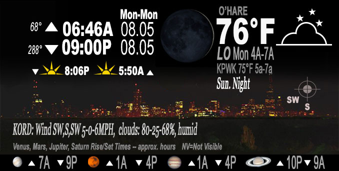
O’HARE FORECAST …
Sunday-Monday Overnight: A 20 percent chance of showers and thunderstorms after 4am. Mostly cloudy, with a steady temperature around 75-77. South southwest wind around 5 mph, with gusts as high as 10 mph.
Monday: A chance of showers and thunderstorms before noon, then a slight chance of showers and thunderstorms after 2pm. Partly sunny, with a high near 90. Heat index values as high as 95. Southwest wind 5 to 10 mph becoming north northeast in the afternoon. Winds could gust as high as 15 mph. Chance of precipitation is 30%.
Monday Night: A 40 percent chance of showers and thunderstorms. Mostly cloudy, with a low around 71. Northeast wind 5 to 10 mph, with gusts as high as 20 mph.
Tuesday: A 30 percent chance of showers and thunderstorms, mainly before 1pm. Mostly cloudy, with a high near 74. East northeast wind 5 to 15 mph, with gusts as high as 25 mph.
Tuesday Night: Partly cloudy, with a low around 65. Northeast wind around 15 mph, with gusts as high as 25 mph.
Wednesday: Mostly sunny, with a high near 78.
Wednesday Night: Partly cloudy, with a low around 64.
Thursday: Mostly sunny, with a high near 82.
Thursday Night: Partly cloudy, with a low around 64.
Friday: Mostly sunny, with a high near 81.
Friday Night: Partly cloudy, with a low around 64.
Saturday: Mostly sunny, with a high near 78.
Saturday Night: Partly cloudy, with a low around 61.
Sunday: Mostly sunny, with a high near 78.
LAKE TEMPS …
SOUTHERN LAKE MICHIGAN WATER TEMPERATURES
NATIONAL WEATHER SERVICE CHICAGO/ROMEOVILLE IL
903 AM CDT Sun Aug 4 2024
LAKE MICHIGAN WATER TEMPERATURES…
CHICAGO SHORE………..76.
CHICAGO CRIB…………75.
CHICAGO BUOY…………76.
WILMETTE BUOY………..76.
WAUKEGAN BUOY………..77.
WINTHROP HARBOR BUOY….76.
MICHIGAN CITY………..71.
MICHIGAN CITY BUOY……76.
SOUTH MID LAKE BUOY…..75.
CENTRAL MID LAKE BUOY…74.
NORTH MID LAKE BUOY…..74.
&&
M IS FOR MISSING DATA THAT IS NORMALLY AVAILABLE.
THE MICHIGAN CITY WATER TEMPERATURE SENSOR IS LOCATED AT
A WATER INTAKE ONE MILE OFFSHORE AND 60 FEET BELOW THE
WATER SURFACE. IT IS READ EVERY DAY OF THE YEAR.
august.chicagoweatherstation.com
Chicago Weather Forecast for your MAC/PC/TABLET includes surrounding suburbs.
^^ MOBILE? USE VOICE MIC ^^
facebook …
Please ‘LIKE’ the ‘Arlington Cardinal Page. See all of The Cardinal Facebook fan pages at Arlingtoncardinal.com/about/facebook …
Help fund The Cardinal Arlingtoncardinal.com/sponsor
Area Forecast Discussion
National Weather Service
Chicago/Romeoville, IL
1208 AM CDT Mon Aug 5 2024
.KEY MESSAGES…
– Waves of showers and thunderstorms possible tonight through Tuesday, with the highest chances (60%) near the Illinois-Wisconsin line.
– Wednesday onward will be marked by pleasant temperatures, low humidity levels, light winds, and slim (15%) chances for rain.
&&
.DISCUSSION… Issued at 327 PM CDT Sun Aug 4 2024
Through Monday Night:
A broad area of high pressure will maintain rain-free, warm, humid conditions through the rest of this afternoon and good portion of the evening. However, the modest shortwave ejecting out of the northern Plains may lead to the development of scattered showers and storms near the IL-WI line this evening and overnight. The big question surrounding the shower/storm potential tonight is whether or not the cluster of showers in eastern SD can erode the mid-level dry air (cap) across southern MN and northern IA and allow for the full utilization of the 1500 to 2500 J/kg of MLCAPE near the stalled frontal boundary in IA and southern WI. Given the modest forcing of the aforementioned wave, guidance continues to struggle on whether or not showers and storms will actually convect ahead of the boundary in WI and force the boundary back into northern IL overnight. Since this forecast is one of lower confidence, the prevailing 20-25% POPs were maintained for this evening and overnight for areas generally along and north of I-88 for this potential but further adjustments will likely be needed based on trends.
Depending on how far south the effective frontal boundary is shifted from tonight`s storms (if at all) will dictate the coverage of showers and storms in northern IL on Monday. While there is obviously some uncertainty as previously stated, the general consensus amongst guidance is for the boundary to set u Psomewhere in between I-88 and I-80. If this does occur as forecast, then scattered showers and thunderstorms should develop along the boundary during the day on Monday as diurnal instability builds with the greatest coverage expected to be north of I-80. While wind profiles on Monday look to be modest at best for a severe threat, 25 to 30 kts of effective shear may still support a marginal (level 1 of 5) threat for an isolated strong to severe storm.
At the same time, another axis of showers and embedded thunderstorms is expected to develop along the 850 mb frontal zone in southern WI and gradually drift southward into northern IL Monday night into Tuesday. While this secondary area of precipitation should have little impact on scattered storm potential on Monday afternoon, it will lead to some hefty rainfall totals especially across WI. Since the heavier rainfall should be waning as this frontal zone pivots into northern IL, the threat for flooding looks to be minimal. However, PWATs in the 1.5 to 1.75 inch range will support the potential for locally heavy downpours which could lead to some ponding issues if shower/storms train over the same areas for extended periods of time.
Aside from the chances for showers and storms, the frontal boundary will also establish a gradient in high temperatures across the area. Areas to north of the boundary (roughly areas north of I-80) will likely see highs in the low to mid-80s with areas south of I-80 seeing readings in the upper 80s to near 90. Furthermore, winds will also vary depending on which side of the boundary locales reside on with breezy north-northeast winds north of the boundary and light south-southwest winds to the south.
Yack
Tuesday through Sunday:
The upper level pattern for this period really holds steady, with high pressure over the desert sw, Tropical Storm Debby across the southeast coast, and two eastward tracking low pressure systems in Canada. This places the Midwest in a squeeze, which will limit the available moisture influx to the region.
As the sfc frontal boundary pulls away from the region Tuesday morning, expect a chance for showers and isolated thunder to persist across far northeast Illinois into northwest Indiana. As a trailing sfc high pressure system shifts across the upper Midwest, this will edge the precipitation into the southern Great Lakes region Tuesday afternoon, bringing a return of drier conditions. With the exit of this system and trailing high, sfc gradients are expected to tighten Tuesday afternoon bringing stronger north-northeast winds to portions of northeast Illinois into northwest Indiana. This setup could result in Lake Michigan shoreline issues, where potentially dangerous swim conditions develop and a small craft product could be needed. With the high pressure system shifting into the southern Great Lakes Wednesday, and then to the northeast coast, this pattern limits the coastal movement of Tropical Storm Debby northward. With the limit of northward progression, and the high pressure drifting into the mid-Atlantic Ocean, storms will struggle to slide back into the Midwest through the second half of this week.
This pattern slowly begins to breakdown heading into next weekend, as another low pressure system ejects out of southern Canada into the Great Lakes. Precipitation odds currently look to be on the low chance (<15%) as this system slides through the region. Temperatures across the region for the period will be slightly below average, with the main exception on Tuesday with a large temperature gradient. High temps along and north of the frontal boundary are forecast in the low 70s, with the potential for a few locations remaining in the upper 60s; while locations across the southern CWA are expected to creep into the mid and upper 80s...along the I-80 corridor temps are forecast in the upper 70s to near 80. Low temps are expected to linger in the upper 50s to low 60s, except in the Chicago metro where mid 60s are forecast. Baker && .AVIATION /06Z TAFS THROUGH 12Z TUESDAY/… Issued at 1208 PM CDT Sun Aug 4 2024
Key Aviation Messages:
– There are multiple chances for showers and thunderstorms through the TAF period (but there no guarantee that they actually occur).
– Light southwesterly winds will turn northeasterly behind a hybrid lake breeze and cold front during daylight hours, and remain northeasterly through the remainder of the TAF period.
Discussion:
Thunderstorms continue to develop near Green Bay, Wisconsin, in response to a passing upper-level wave interacting with a conditionally unstable airmass. With the same conditionally unstable airmass in place across southern Wisconsin and far northern Illinois, we continue to assess a threat for additional thunderstorms developing close to the terminals at some point early this morning. For this reason, felt that maintaining the inherited TEMPO groups at all terminals for thunder would be the course of least regret. AMDs, including the possible removal of thunder, will be made as trends become established overnight.
Throughout daylight hours, a hybrid lake breeze and cold frontal boundary (possibly augmented by convection) is expected to move across the terminals from northeast to southwest. The inherited timing of the northeasterly wind shift remains appropriate.
Additional thunderstorms may develop this afternoon as subtle upper-level ripples propagate along the frontal boundary. Confidence in where, when, and even if thunderstorms will develop remains too low to include a formal mention in the TAF.
Finally, additional thunderstorms with damaging hail and winds may come close to RFD/ORD/MDW toward the end of the 24 to 30-hour TAF windows associated with gravity waves embedded within a narrow band of frontogenesis. At this point, the favored zone for gravity wave propagation is near and north of the Wisconsin state line.
Borchardt
&&
.LOT WATCHES/WARNINGS/ADVISORIES…
IL…None.
IN…None.
LM…None.