

Dew points have been in the 70s overnight. There is only a light dew on the grass.
There was a Heat Index all night ranging 90°F to 75°F. Wind was less than 7 MPH from the South and Southwest.
Showers and thunderstorms were nearby overnight but passing southwest of the northwest suburbs. Showers and storms this morning will likely occur south of a Dixon to Rensselaer line. A gusty wind threat may materialize after daybreak south of I-80, but severe weather is not anticipated.
Additional scattered strong-severe storms possible late this afternoon and into the evening in Chicagoland.
After ending Friday around 4:00 p.m., an active pattern of showers and thunderstorm may return early next week.
Weather Radar at 5:35 a.m. Thursday, August 1, 2024 shows precipitation growing slightly and moving east.
See also Arlingtoncardinal.com/clouds
Periodic shower and storm chances will continue this morning, this afternoon into this evening and again on Friday. The precipitation on Friday is expected to be mainly showers with only a few thunderstorms possible. #ILWX #INWX pic.twitter.com/EaXbSxYMo8
— NWS Chicago (@NWSChicago) August 1, 2024
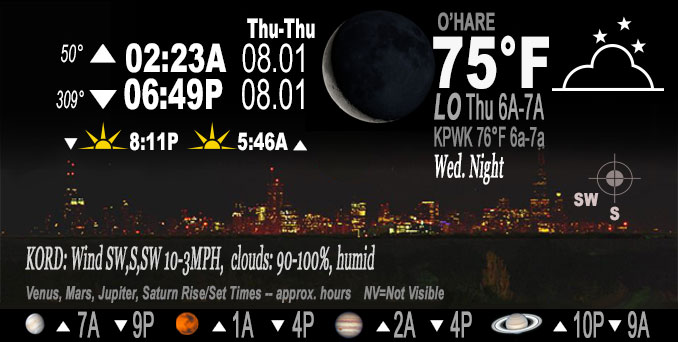
O’HARE FORECAST …
Thursday: A 40 percent chance of showers and thunderstorms, mainly after 4pm. Mostly cloudy, with a high near 87. South southwest wind 5 to 10 mph.
Thursday Night: Showers and thunderstorms likely, mainly between 7pm and 10pm. Mostly cloudy, with a low around 71. Southwest wind around 5 mph becoming north northwest after midnight. Chance of precipitation is 70%. New rainfall amounts between a quarter and half of an inch possible.
Friday: Showers likely and possibly a thunderstorm before 1pm, then a chance of showers and thunderstorms between 1pm and 4pm. Cloudy, then gradually becoming mostly sunny, with a high near 82. North northeast wind 5 to 15 mph, with gusts as high as 25 mph. Chance of precipitation is 70%. New rainfall amounts between a tenth and quarter of an inch, except higher amounts possible in thunderstorms.
Friday Night: Mostly clear, with a low around 69. North wind 5 to 10 mph, with gusts as high as 15 mph.
Saturday: Sunny, with a high near 88. North northeast wind 5 to 10 mph, with gusts as high as 15 mph.
Saturday Night: Mostly clear, with a low around 69.
Sunday: Mostly sunny, with a high near 89.
Sunday Night: Mostly cloudy, with a low around 69.
Monday: Mostly cloudy, with a high near 83.
Monday Night: A chance of showers and thunderstorms after 1am. Mostly cloudy, with a low around 69.
Tuesday: A chance of showers and thunderstorms. Mostly sunny, with a high near 82.
Tuesday Night: A chance of showers and thunderstorms. Mostly cloudy, with a low around 66.
Wednesday: Partly sunny, with a high near 79.
LAKE TEMPS …
SOUTHERN LAKE MICHIGAN WATER TEMPERATURES
NATIONAL WEATHER SERVICE CHICAGO/ROMEOVILLE IL
940 AM CDT Wed Jul 31 2024
LAKE MICHIGAN WATER TEMPERATURES…
CHICAGO SHORE………..74.
CHICAGO CRIB…………73.
CHICAGO BUOY…………75.
WILMETTE BUOY………..75.
WAUKEGAN BUOY………..75.
WINTHROP HARBOR BUOY….74.
MICHIGAN CITY………..66.
MICHIGAN CITY BUOY……75.
SOUTH MID LAKE BUOY…..74.
CENTRAL MID LAKE BUOY…71.
NORTH MID LAKE BUOY…..71.
&&
THE MICHIGAN CITY WATER TEMPERATURE SENSOR IS LOCATED AT A WATER INTAKE ONE MILE OFFSHORE AND 60 FEET BELOW THE WATER SURFACE. IT IS READ EVERY DAY OF THE YEAR.
august.chicagoweatherstation.com
Chicago Weather Forecast for your MAC/PC/TABLET includes surrounding suburbs.
^^ MOBILE? USE VOICE MIC ^^
facebook …
Please ‘LIKE’ the ‘Arlington Cardinal Page. See all of The Cardinal Facebook fan pages at Arlingtoncardinal.com/about/facebook …
Help fund The Cardinal Arlingtoncardinal.com/sponsor
Area Forecast Discussion
National Weather Service
Chicago/Romeoville, IL
204 AM CDT Thu Aug 1 2024
.KEY MESSAGES…
– Showers and storms this morning, with the greatest chances south of a Dixon to Rensselaer line. A gusty wind threat may materialize after daybreak south of I-80, but severe weather is not anticipated.
– Additional scattered strong-severe storms possible late this afternoon and into the evening.
– Possible active pattern returns early next week with shower/thunderstorm chances returning.
&&
.DISCUSSION… Issued at 203 AM CDT Thu Aug 1 2024
Through Friday:
A remnant outflow boundary from a previously intense MCS is moving east of the Mississippi River at press time. Latest objective analysis reveals limited mid and upper-level flow, leading to paltry deep layer shear. Additionally, a notable moisture gradient/discontinuity exists with eastward extent, likely leftover from yesterday`s convective episodes. The resulting profiles look like typical “onion” soundings, with a moist 600-400 mb layer, near dry adiabatic dry layer underneath, and lingering shallow inverted layer near the surface. These thermodynamic setups are not overly favorable for vigorous convection in the absence of a mature/severe MCS. As such, outflow is expected to remain along and ahead of any new convective cores, with activity preferentially building more south and eastward through early this morning into the 925-850 mb theta-e axis. Have confined the highest PoPs through mid-morning south of about a Dixon to Rensselaer line as a result. Generally expect this leading activity to slowly diminish in intensity.
Farther to the west across central Iowa, an expansive outflow boundary with notable undular bore characteristics–exhausted from earlier robust MCS activity across southern Minnesota–is just now meandering south of I-80. Across southern Iowa, a modest westerly low-level jet of 35 knots is developing and as this impinges on the outflow, suspect renewed convective clusters will try to pop in a W-E axis within a locally enhanced 925-850 mb moist layer. Unsure just how expansive this activity will become, but conceptually soundings look supportive of scattered to even numerous showers and storms materializing across southern Iowa and then tracking eastward. Once again, any activity would preferentially track east to southeastward, with the greatest coverage again south of about a Dixon to Rensselaer or DeMotte line. *IF* this activity can sustain, suppose there might be a modestly higher chance for some gustier winds as the 700 mb flow is forecast to increase a smidge. This would all be after sunrise into the mid-morning hours and relegated to our far far southern locales.
With fairly extensive debris cloud cover and showers around, continued to cut high temperatures for today. If we clear out more than expected, temperatures would certainly need a boost. An additional round of scattered showers and thunderstorms is then expected late this afternoon into the evening as a cold front approaches ahead of a well-defined upper low/vort packet. Dee Player shear won`t be particularly high, less than 30 knots based on most guidance suggesting that pulse/multicell clusters will be the dominant storm mode. A strong to perhaps localized damaging wind gust and marginally-severe hail threat will be supported in this environment, with a somewhat later show mostly after 4 pm given the morning cloud cover. Low-level shear is also forecast to remain suppressed today, although does look to locally increase a bit well south of I-80 early this evening. With a very moist boundary layer in place, low LCLs, and what look to be plentiful near-surface confluence axes in place, some funnel clouds (upper low “funny business” as we`ve said in the past) can`t be ruled out.
The short-wave trough will become a closed low by early Friday over the interior central or eastern CWA. Thunderstorm coverage should steadily diminish in the late evening and overnight tonight as instability quickly wanes, though with enough large scale support for scattered showers “festering” into the overnight. Variable cell motions under 10 mph could lead to a highly localized heavy rainfall threat from any more developed cores, but this would not be on a widespread basis. Friday will likely be showery, especially in the morning into the early afternoon, due to the proximity of the upper low, with embedded thunder most favored in far interior sections, especially I-80 and south. There continues to be a signal for a localized corridor of heavier/steadier rainfall rates setting up in the vicinity of the lakefront as enhanced surface convergence develops with the upper low essentially right overhead. Jet level winds are not forecast to be high, but subtly increased upper divergence may foster slow-moving heavier showers and embedded storms that we`ll have to keep an eye on through the morning hours, including over downtown Chicago.
Shower activity will probably wind down/scour out in the afternoon from north-northeast to south-southwest with cooler and slightly drier air working its way inland from the lake. Thus, for interests in downtown Chicago, the afternoon forecast appears to be trending more favorably. Temperatures will top out in the lower 80s inland, and upper 70s near the lake due to onshore flow.
– Carlaw/NWS Chicago
Friday Night through Wednesday:
There may be a few lingering showers across northwest IN Friday evening, but overall, the weekend is looking dry and warm with highs in the mid/upper 80s both days, but cooler near the lake with onshore winds. By Sunday afternoon/evening, there will be a slight chance of a shower/thunderstorm across far northern IL as a frontal boundary sags south across the western Great Lakes. This frontal boundary will likely be in or just south of the area through the middle of next week allowing for another possible unsettled pattern with chances for showers and thunderstorms. The blended pops have increased with some amount of low chance pops from Sunday evening through Wednesday night and this seems reasonable given the pattern. Temperatures will be tricky, likely upper 70s/lower 80s north of the front, possibly 90ish south of the front.
-cms/NWS Chicago
&&
.AVIATION /06Z TAFS THROUGH 12Z FRIDAY/… Issued at 1227 AM CDT Thu Aug 1 2024
Forecast concerns include…
Chance of thunderstorms this morning. Chance of thunderstorms this afternoon into this evening. Chance of showers overnight/Friday morning. Possible fog/log cigs late tonight/Friday morning.
The models are in general agreement that the current convection moving from far eastern IA into west central IL will have a general east/southeast motion with weakening expected on the northern edge. Its possible that all that remains for the terminals is showers, with perhaps isolated thunder for the mid morning hours. However, its prudent to keep some thunder mention included for now and opted to keep the tempo and remove the prevailing. Timing also looks later and after sunrise for the Chicago terminals.
A lull is expected from late morning through mid afternoon and then there will be another chance for thunderstorms this afternoon into this evening. Current prob mention has this handled well for now. There remains quite a bit of uncertainty for coverage and even timing and adjustments are possible with later forecasts. There may be lingering showers through the late evening and overnight but additional showers and perhaps isolated thunder are possible toward sunrise Friday morning as an upper level low moves across the area.
Winds will generally remain south/southwest through early this evening, though wind directions may be effected by outflow boundaries from storms. Low confidence for wind directions this evening. Just about every model has a different wind direction. As a weak low passes to the east, winds should turn northwest or northerly and then eventually turn northeast by daybreak Friday morning, but refinement to this forecast can be expected.
Models are showing the potential for fog and low cigs late tonight into Friday morning. Both may be dependent on preci Pcoverage with at least mvfr vis and mvfr cigs would be possible but no mention with this forecast.
– cms/NWS Chicago
&&
.LOT WATCHES/WARNINGS/ADVISORIES… IL…None. IN…None. LM…None.
 Amazon Best Sellers in Audible Books