

Severe thunderstorms did not material in northwest Cook County; however, the conditional threat of severe thunderstorms late this afternoon continues into the evening.
Another round of storms possible early Tuesday morning mainly north of I-80, a few showers/storms could then linger across eastern IL/northwest IN into the afternoon.
Sharp temperature gradient across the area on Tuesday, with highs in the 70s to near 80 north of I-80 and 80s to near 90 south of I-80.
High waves and dangerous swimming conditions are forecast at Lake Michigan beaches Tuesday through Wednesday.
Wednesday through Monday will have seasonal temperatures, lower humidity levels, light winds, and slim (<10%) chances for regional rainfall.
Weather Radarat 9:05 p.m. Monday, August 5, 2024 shows precipitation dissipating and moving to the east.
Around 8:00 p.m. CDT Monday there were severe thunderstorms and a Tornado Warning (radar indicated) around Lake Summerset Illinois, northwest of Rockford.
See also Arlingtoncardinal.com/clouds
Scattered storms are expected to continue to move over the area through the night with the potential to develop stronger winds, hail, and locally heavier rainfall. #ILwx #INwx pic.twitter.com/ve5vIX5MAM
— NWS Chicago (@NWSChicago) August 6, 2024
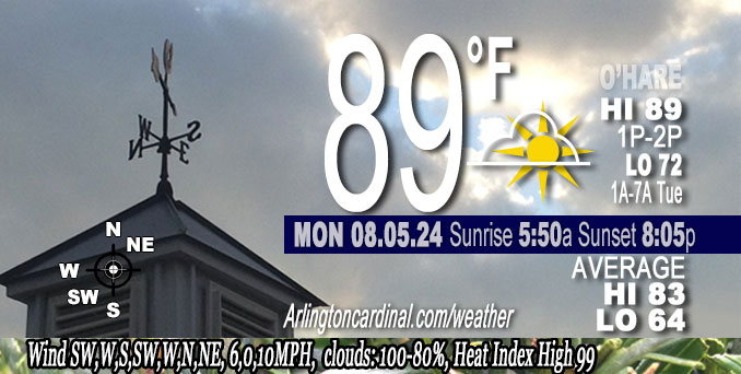
O’HARE FORECAST …
Monday Night: A 50 percent chance of showers and thunderstorms, mainly after 3am. Mostly cloudy, with a low around 72. East northeast wind 5 to 10 mph, with gusts as high as 15 mph.
Tuesday: A 30 percent chance of showers and thunderstorms, mainly before 1pm. Mostly cloudy, with a high near 74. East southeast wind 10 to 15 mph becoming north northeast in the afternoon. Winds could gust as high as 30 mph.
Tuesday Night: Cloudy, then gradually becoming partly cloudy, with a low around 65. Northeast wind around 15 mph, with gusts as high as 25 mph.
Wednesday: Mostly sunny, with a high near 78. Northeast wind 10 to 15 mph.
Wednesday Night: Mostly clear, with a low around 64. East wind 5 to 10 mph, with gusts as high as 15 mph.
Thursday: Mostly sunny, with a high near 81.
Thursday Night: Partly cloudy, with a low around 63.
Friday: Mostly sunny, with a high near 79.
Friday Night: Partly cloudy, with a low around 61.
Saturday: Sunny, with a high near 77.
Saturday Night: Mostly clear, with a low around 61.
Sunday: Sunny, with a high near 79.
Sunday Night: Mostly clear, with a low around 62.
Monday: Mostly sunny, with a high near 82.
LAKE TEMPS …
SOUTHERN LAKE MICHIGAN WATER TEMPERATURES
NATIONAL WEATHER SERVICE CHICAGO/ROMEOVILLE IL
916 AM CDT Mon Aug 5 2024
LAKE MICHIGAN WATER TEMPERATURES…
CHICAGO SHORE………..76.
CHICAGO CRIB…………71.
CHICAGO BUOY…………77.
WILMETTE BUOY………..77.
WAUKEGAN BUOY………..78.
WINTHROP HARBOR BUOY….77.
MICHIGAN CITY………..63.
MICHIGAN CITY BUOY……74.
SOUTH MID LAKE BUOY…..76.
CENTRAL MID LAKE BUOY…74.
NORTH MID LAKE BUOY…..72.
&&
THE MICHIGAN CITY WATER TEMPERATURE SENSOR IS LOCATED AT A WATER INTAKE ONE MILE OFFSHORE AND 60 FEET BELOW THE WATER SURFACE. IT IS READ EVERY DAY OF THE YEAR.
august.chicagoweatherstation.com
Chicago Weather Forecast for your MAC/PC/TABLET includes surrounding suburbs.
^^ MOBILE? USE VOICE MIC ^^
facebook …
Please ‘LIKE’ the ‘Arlington Cardinal Page. See all of The Cardinal Facebook fan pages at Arlingtoncardinal.com/about/facebook …
Help fund The Cardinal Arlingtoncardinal.com/sponsor
Area Forecast Discussion
National Weather Service
Chicago/Romeoville, IL
704 PM CDT Mon Aug 5 2024
.KEY MESSAGES…
– Conditional threat of severe thunderstorms late this afternoon into the evening
– Another round of storms possible early Tuesday morning mainly north of I-80, a few showers/storms could then linger across eastern IL/northwest IN into the afternoon.
– Sharp temperature gradient across the area on Tuesday, with highs in the 70s to near 80 north of I-80 and 80s to near 90 south of I-80.
– High waves and dangerous swimming conditions at Lake Michigan beaches Tuesday through Wednesday.
– Wednesday through Monday will have seasonal temperatures, lower humidity levels, light winds, and slim (<10%) chances for regional rainfall. && .DISCUSSION… Issued at 300 PM CDT Mon Aug 5 2024
Through Tuesday:
Surface low pressure is currently centered across southeast South Dakota. A surface boundary extends east southeast of the low across northern Iowa and northern Illinois late this afternoon. With much of the area situated within the warm sector south of this boundary, hot and humid conditions have developed with heat indices in the upper 90s to lower 100s. A sharp lake enhanced cold front is now moving inland across portions of Lake and Cook Counties in Illinois where temperatures have already cooled into the 70s. This boundary will continue advance southwest this afternoon and evening, providing relief from the heat in its wake.
We are closely monitoring for the potential for thunderstorm development this afternoon, (currently 20-40% chance). The atmosphere is highly unstable with MUCAPE of 3500-4000+ J/kg in place. This suggests that if storms can form they could see explosive development. The main question remains whether storms in fact develop. There are two surface boundaries/convergence axes that could serve as potential sources of lift. One extending from near Rockford northwest through southwest Wisconsin. A second weaker convergence axis lies near the Kankakee River Valley and points west through central LaSalle County. Effective bulk shear is not especially strong initially, particularly south of I-88, though areas closer to the WI/IL stateline will increase to greater than 45 kts by early evening. This would support the potential for damaging winds and hail with any storms that develop. A brief tornado also can`t be ruled out mainly north of I-88 and west of the metro where the lower-level shear becomes slightly more favorable. CAMs suggest storms will develop in the vicinity of these boundaries west of the Chicago metro and gradually drift east to east southeast with time. Suspect that the window for severe storms may be fairly short with storm intensity expected to decrease with eastward extent as they move into a cooler, less stable environment behind the aforementioned lake enhanced boundary.
A decrease in shower/storm coverage is probable toward midnight before the surface low approaches from the west late tonight. Expect increasing shower/storm coverage once again, particularly north of I-80 and toward the Illinois-Wisconsin stateline overnight. THese storms will be capable of heavy rain and gusty winds. A localized damaging wind gust also can`t be ruled out, though confidence in storms maintaining intensity through northern Illinois remains low. If a more southerly track of storms verifies, training of storms across the same areas in far northern Illinois could lead to some flooding.
By daybreak Tuesday storms may be ongoing across the Chicago metro into northwest Indiana. Depending on how quickly they exit to the southeast in the morning, we may be shower/thunderstorm free as early as the afternoon. If showers/storms are a bit slower to exit, renewed destabilization across northwest Indiana could allow for a couple strong to marginally severe storm to develop before it exits out of the area by the evening.
A sharp temperature gradient is expected on Tuesday thanks to a cold front sagging south across the area turning winds northerly and breezy. Temperatures along and north of I-80 may struggle to warm out of the 70s while areas south of I-80 could still warm into the 80s to near 90s (heat indices in the 90s) prior to the frontal passage.
– Petr/NWS
Northeast winds may increase into the 20 mph range over southern Lake Michigan this afternoon into early this evening, allowing waves to possibly build into the 2-4 ft range, especially for the IL shore of Lake Michigan. Winds may diminish slightly this evening but as the main cold front moves south across southern Lake Michigan Tuesday morning, northerly winds will steadily increase and likely into the 30-35 mph range over southern Lake Michigan Tuesday afternoon/evening. These winds will allow waves to build into the 6-9 ft range and create dangerous swimming conditions at Lake Michigan beaches, that will likely persist well into Wednesday morning, and possibly Wednesday afternoon depending on how fast winds begin to relax. cms
Tuesday Night through Monday:
There may be a few lingering showers in northwest IN early Tuesday evening otherwise, dry weather is expected for the rest of the extended period. There may also be a small chance for a few showers over the weekend near and over Lake Michigan. Confidence is too low for any precip mention during this time period. Temperatures are expected to be near seasonal normals for early/mid August with lower humidity levels. Northeasterly winds will likely keep temps a few degrees cooler near Lake Michigan. cms
&&
.AVIATION /00Z TAFS THROUGH 06Z WEDNESDAY/… Issued at 704 PM CDT Mon Aug 5 2024
The primary aviation weather concerns for the 00Z TAF period include:
* Isolated to widely scattered thunderstorms into this evening
* Additional rain possible late tonight into early Tuesday
* MVFR cigs expected with IFR possible late tonight through the day on Tuesday
Widely scattered thunderstorms are expected to persist around northern IL into mid-evening before dissipating. An additional system of showers is expected to work across southern WI overnight into Tuesday morning which could possibly extend far enough south to drop some intermittent light showers on the airfields, RFD in particular. The rain potential will move away by mid-morning.
MVFR cigs are expected to move over the terminals late tonight and stick around through Tuesday. A period of IFR cigs also appears very attainable, particularly during the morning, but confidence isn`t quite there yet to include IFR in the TAF.
Meanwhile, NE winds near 10 kt should mostly subside for the night but could try and stay up near that 10 kt mark from time to time. We`ll see winds accelerate through the morning gusting to around 20 to 25 kt for the better part of the day with a chance for occasional gusts over 30 kt. They`ll subside some but should continue gusting to near 20 kt through the evening.
Doom
&&
.LOT WATCHES/WARNINGS/ADVISORIES… IL…Beach Hazards Statement through Wednesday afternoon for ILZ006.
Beach Hazards Statement from Tuesday morning through Wednesday afternoon for ILZ103-ILZ104.
IN…Beach Hazards Statement from Tuesday afternoon through Wednesday afternoon for INZ001-INZ002.
LM…Small Craft Advisory until 3 PM CDT Wednesday for Winthrop Harbor to Wilmette Harbor IL.
Small Craft Advisory from 10 AM Tuesday to 3 PM CDT Wednesday for Wilmette Harbor to Calumet Harbor IL.
Small Craft Advisory from 1 PM Tuesday to 3 PM CDT Wednesday for the IN nearshore waters.