
Funnel Clouds Possible Early This Evening in McHenry Area
Northwest of Arlington Heights in McHenry County, atmospheric conditions are favorable for the development of funnel clouds. These funnel clouds normally only protrude a few hundred feet downward from the parent cloud, rotate or spin like a top, and last a few minutes before dissipating.
These funnel clouds rarely touch the ground and typically do not pose any sort of hazard. The atmospheric conditions that these funnel clouds develop in do not support strong, damaging tornadoes. However, on extremely rare occasions, these funnels can briefly touch the ground and produce very minimal, if any, damage.
If threatening weather approaches, move indoors to a place of safety. The National Weather Service reported that the Chicago office will continue to closely monitor the situation.
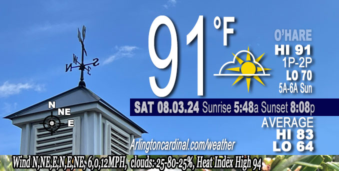
In Arlington Heights and northwest Cook County, and near O’Hare International Airport, there is a chance (15-20%) for spotty showers along the lake, and near I-39 this afternoon.
A few episodes of showers and storms may occur near the Wisconsin state line Sunday night through Tuesday.
A cooler and less humid pattern will prevail from the middle of next week onward.
Weather Radar at 6:00 p.m. Saturday, August 3, 2024 in northeast Illinois was clear.
See also Arlingtoncardinal.com/clouds
The relatively warm and humid pattern will continue through early next week, and break in the wake of a storm system on Tuesday. Chances for showers and storms will continue today in northeastern IL, and near the Wisconsin state line Sunday night through Monday night. #ILwx #INwx pic.twitter.com/iB9JIVitaQ
— NWS Chicago (@NWSChicago) August 3, 2024
O’HARE FORECAST …
Saturday Night: Mostly clear, with a low around 70. East northeast wind 5 to 10 mph becoming light and variable in the evening.
Sunday: Mostly sunny, with a high near 90. Light west southwest wind increasing to 5 to 10 mph in the morning.
Sunday Night: A 20 percent chance of showers and thunderstorms after 1am. Partly cloudy, with a low around 72. Southwest wind around 5 mph becoming north northeast after midnight.
Monday: A 30 percent chance of showers and thunderstorms, mainly after 1pm. Partly sunny, with a high near 88. West southwest wind 5 to 10 mph becoming east northeast in the afternoon. Winds could gust as high as 15 mph.
Monday Night: A 50 percent chance of showers and thunderstorms. Mostly cloudy, with a low around 69. East northeast wind around 10 mph, with gusts as high as 15 mph.
Tuesday: A 30 percent chance of showers and thunderstorms before 1pm. Mostly cloudy, with a high near 76.
Tuesday Night: Partly cloudy, with a low around 64.
Wednesday: Mostly sunny, with a high near 78.
Wednesday Night: Partly cloudy, with a low around 64.
Thursday: Mostly sunny, with a high near 77.
Thursday Night: Partly cloudy, with a low around 62.
Friday: Mostly sunny, with a high near 76.
Friday Night: Mostly clear, with a low around 60.
Saturday: Mostly sunny, with a high near 77.
LAKE TEMPS …
SOUTHERN LAKE MICHIGAN WATER TEMPERATURES
NATIONAL WEATHER SERVICE CHICAGO/ROMEOVILLE IL
902 AM CDT Sat Aug 3 2024
LAKE MICHIGAN WATER TEMPERATURES…
CHICAGO SHORE………..74.
CHICAGO CRIB…………73.
CHICAGO BUOY…………75.
WILMETTE BUOY………..75.
WAUKEGAN BUOY………..75.
WINTHROP HARBOR BUOY….75.
MICHIGAN CITY………..56.
MICHIGAN CITY BUOY……75.
SOUTH MID LAKE BUOY…..75.
CENTRAL MID LAKE BUOY…74.
NORTH MID LAKE BUOY…..73.
THE MICHIGAN CITY WATER TEMPERATURE SENSOR IS LOCATED AT
A WATER INTAKE ONE MILE OFFSHORE AND 60 FEET BELOW THE
WATER SURFACE. IT IS READ EVERY DAY OF THE YEAR.
august.chicagoweatherstation.com
Chicago Weather Forecast for your MAC/PC/TABLET includes surrounding suburbs.
^^ MOBILE? USE VOICE MIC ^^
facebook …
Please ‘LIKE’ the ‘Arlington Cardinal Page. See all of The Cardinal Facebook fan pages at Arlingtoncardinal.com/about/facebook …
Help fund The Cardinal Arlingtoncardinal.com/sponsor
Area Forecast Discussion
National Weather Service
Chicago/Romeoville, IL
254 PM CDT Sat Aug 3 2024
.KEY MESSAGES…
– Chance (15-20%) for spotty showers along the lake breeze and near I-39 this afternoon.
– A few episodes of showers and storms may occur near the Wisconsin state line Sunday night through Tuesday.
– A cooler and less humid pattern will prevail from the middle of next week onward.
&&
.DISCUSSION… Issued at 254 PM CDT Sat Aug 3 2024
Through Sunday:
Modest upper-level ridging continues to build overhead this afternoon which has generally kept skies mostly sunny and allowed temperatures to warm into the upper 80s and lower 90s. However, there is a modest 700 mb wave diving across western IL which has developed some spotty showers near and west of I-39. Forecast soundings continue to show that a modest cap is in place which should limit the coverage and overall intensity, but the potential for at least spotty showers will persist through early evening. Additionally, there is a lake breeze moving inland across northern IL which may also serve as a focus for spotty shower development this afternoon. Given these trends I have expanded the 15% POPs westward towards the I-39 corridor to account for the shower potential, but suspect most area will remain rain-free.
Any showers that do materialize will taper prior to sunset leaving a quiet and humid night for us. While skies should generally remain cloud-free there is some cirrus from a cluster of storms in Minnesota that may drift overhead through the night. Regardless, temperatures are expected to cool into the mid to upper 60s with lower 70s for the heart of the Chicago metro. Though there is the chance, albeit low, for some shallow ground fog to develop tonight as temperatures cool near the dew points. Since there is some uncertainty as to coverage and location of any fog I have foregone a formal mention in the forecast, but will continue to monitor trends this evening. Any fog that does develop should only result in minor visibility reductions (generally in the 4 to 6 mile range) and will dissipate shortly after sunrise.
Sunday will once again be another warm and humid August day with highs in the upper 80s and lower 90s. While skies will start off in the mostly clear category, cloud cover is expected to gradually increase into the partly cloudy range as a shortwave disturbances pivots into the Upper Midwest. Otherwise, expect rain-free conditions and light southwest winds.
Yack
Sunday Night through Saturday:
Sunday night and Monday, a frontal boundary is expected to stall in the vicinity of southern Wisconsin in response to a developing surface low in the northern Plains. Weak ripples embedded in the quasi-zonal flow aloft with associated forcing for ascent atop pooling low-level moisture near the front will support periodic episodes of showers and storms. Meanwhile, neutral height tendencies, weak capping, and a pocket of dry air below 700mb should limit coverage of storms south from the front (across much of our area). With this in mind, the blended NBM PoPs ranging from 20% near I-88 to 40% closer to the front and near the Wisconsin state line Sunday night through Monday makes sense. Where storms do develop, forecast kinematic profiles will be supportive of supercell structures with an associated threat for severe weather. Again, highest coverage of storms should be tied to the front, with the highest chances in southern Wisconsin.
Outside of chances for showers and storms, Monday is looking to be a warm and muggy day. Forecast 925/850mb temperatures of +23/20C will support afternoon highs around 90F, save for near the Illinois shoreline of Lake Michigan where a lake breeze will usher in temperatures in the mid to upper 70s. When combined with surface dew points in the lower 70s, partly cloudy skies, and light winds, forecast wet bulb globe temperatures will peak in the mid 80s (peak heat indices near 100), which is typically where heat related illnesses can arise in the absence of preventative measures. While it is August and a period of time typically characterized by hot temperatures, be sure to practice heat safety tips if planning to participate in activities outdoors for a prolonged period of time on Monday.
Monday night into Tuesday, the aforementioned surface low (which will be compact in nature) is expected to pass through the Lower Great Lakes. Ensemble model guidance exhibits spread on the exact track of compact surface low, though there is consensus on it passing through the northern halves of Illinois/Indiana. Along and north of the path of the surface low (near the frontal boundary), a narrow band of frontogenetically- driven showers and storms is expected, at this point favoring southern Wisconsin and areas near the Wisconsin state line. With the combined effects of synoptic- scale (i.e. frontogenetical) and convective (i.e. upright instability) forcing acting upon PWATs forecasted to be near 1.75″, a narrow swath of heavy rain with 12-hour rainfall totals >1″ may occur along and north of the path of the low.
A period of breezy north to northeasterly winds Monday night into Tuesday along the backside of the system will cause choppy waves and dangerous swimming conditions for Lake Michigan beaches.
In the wake of the system, Tuesday onward will be noticeably less humid and cooler, with daily highs in the upper 70s to around 80. With the upper-level jet positioned to our north and a surface high expected to stall over the Great Lakes vicinity, chances for widespread rainfall after Tuesday appears slim (<10%). Ensemble meteograms of QPF suggest a weak signal for more meaningful rain to arrive in the middle of the month. Borchardt && .AVIATION /18Z TAFS THROUGH 00Z MONDAY/… Issued at 1230 PM CDT Sat Aug 3 2024
Winds remain light and variable across the region, but a lake breeze is expected to move inland between 19Z-21Z for more persistent winds out of the northeast. A weak mid level wave moving over the area has provided some cumulus cloud development over the area. As this wave interacts with the lake breeze, a few showers may develop this afternoon. Better chances are farther inland (RFD or DPA), but coverage and probability of occurrence remains too low to add to the TAFs – though it will be monitored closely.
Winds will become light and variable after sunset and with only some high clouds in the area (which could add insolation to make this a non issue), there is a chance for some lower vis to develop. Better chances are farther west away from the city, though confidence is low and dense fog is not expected. Winds will turn to the southwest Sunday morning and slowly increase to 10 to 15 knots in the afternoon under VFR conditions.
DK
&&
.LOT WATCHES/WARNINGS/ADVISORIES… IL…None. IN…None. LM…None.