

Severe thunderstorms are in the area, including 70 MPH winds warned in the Kane County area with a Severe Thunderstorm Warning Sunday night. Severe Thunderstorm Watch in effect from July 14, 05:55 PM CDT until July 15, 01:00 AM CDT for northern Illinois.
Arlington Heights and northwest Cook County could experience around one inch of rain with high winds and intense lightning.
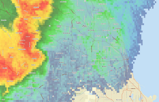
Weather Radar shows strong thunderstorm moving across the entire northern Illinois region.
Severe storms have been fluctuating in intensity, and a particularly strong cell was approaching South Elgin and Elgin at about 9:50 p.m. progress to affect Schaumburg, Palatine, Rolling Meadows, Arlington Heights and other communities nearby. However, the radar forecast indicates the severe weather will pass on a more southerly track through Bloomingdale and Elmhurst.
At about 10:06 p.m. Severe Thunderstorm Warning was issued just the southern tip of Arlington Heights and much of Cook County south of Arlington Heights. This article doesn’t include all weather warnings … just a sampling.
See also Arlingtoncardinal.com/clouds
Severe Thunderstorm Warning including Chicago IL, Cicero IL and Evanston IL until 11:00 PM CDT pic.twitter.com/EXPXuw2Med
— NWS Chicago (@NWSChicago) July 15, 2024
A severe thunderstorm watch has been issued for parts of Illinois, Indiana, Iowa and Wisconsin until 1 AM CDT pic.twitter.com/RIRakVtRhk
— NWS Chicago (@NWSChicago) July 14, 2024
(1/6) Strong to severe storms are expected late this afternoon and into the overnight. All severe hazards are possible. See the graphic for additional details on approximate thunderstorm onset times. pic.twitter.com/tUdrUDqUTN
— NWS Chicago (@NWSChicago) July 14, 2024
O’HARE FORECAST …
Sunday Night: Showers and thunderstorms, mainly before 1am. Some of the storms could be severe and produce heavy rainfall. Low around 72. South wind 5 to 10 mph becoming west southwest after midnight. Chance of precipitation is 90%. New rainfall amounts between a half and three quarters of an inch possible.
Another round of severe thunderstorms is possible Monday night after 6:00 p.m. with at least an inch of rain.
Monday: A 20 percent chance of showers and thunderstorms after 1pm. Mostly sunny, with a high near 93. Heat index values as high as 103. South southwest wind 5 to 15 mph, with gusts as high as 20 mph.
Monday Night: Showers and thunderstorms, mainly between 7pm and 1am. Some of the storms could be severe and produce heavy rainfall. Low around 72. West southwest wind 10 to 15 mph, with gusts as high as 25 mph. Chance of precipitation is 80%. New rainfall amounts between 1 and 2 inches possible.
Tuesday: A 40 percent chance of showers and thunderstorms. Partly sunny, with a high near 84. West southwest wind 5 to 10 mph becoming north northeast in the afternoon.
Tuesday Night: Partly cloudy, with a low around 66. North northeast wind around 5 mph becoming calm in the evening.
Wednesday: Mostly sunny, with a high near 81.
Wednesday Night: Mostly clear, with a low around 62.
Thursday: Sunny, with a high near 76.
Thursday Night: Clear, with a low around 58.
Friday: Sunny, with a high near 79.
Friday Night: Mostly clear, with a low around 60.
Saturday: Sunny, with a high near 82.
Saturday Night: Partly cloudy, with a low around 63.
Sunday: Mostly sunny, with a high near 84.
LAKE TEMPS …
SOUTHERN LAKE MICHIGAN WATER TEMPERATURES
NATIONAL WEATHER SERVICE CHICAGO/ROMEOVILLE IL
1014 AM CDT Sun Jul 14 2024
LAKE MICHIGAN WATER TEMPERATURES…
CHICAGO SHORE………..73.
CHICAGO CRIB…………66.
CHICAGO BUOY…………71.
WILMETTE BUOY………..71.
WAUKEGAN BUOY………..68.
WINTHROP HARBOR BUOY….69.
MICHIGAN CITY BUOY……72.
SOUTH MID LAKE BUOY…..70.
CENTRAL MID LAKE BUOY…68.
NORTH MID LAKE BUOY…..67.
july.chicagoweatherstation.com
Chicago Weather Forecast for your MAC/PC/TABLET includes surrounding suburbs.
^^ MOBILE? USE VOICE MIC ^^
facebook …
Please ‘LIKE’ the ‘Arlington Cardinal Page. See all of The Cardinal Facebook fan pages at Arlingtoncardinal.com/about/facebook …
Help fund The Cardinal Arlingtoncardinal.com/sponsor
Area Forecast Discussion
National Weather Service
Chicago/Romeoville, IL
652 PM CDT Sun Jul 14 2024
.KEY MESSAGES…
– Additional clusters of storms are expected through this evening, with continued threats for severe weather and flash flooding.
– Hot and very humid on Monday with heat indices of 100-110F and a Heat Advisory likely needed for at least portions of the area.
– Additional rounds of thunderstorms are expected late day Monday-Monday night (area wide) and on Tuesday (mainly I-55 and southeast) with continued severe and flash flood threats.
– The pattern finally breaks Tuesday night into Wednesday with a return of tranquil conditions late Wednesday onward.
&&
.DISCUSSION… Issued at 320 PM CDT Sun Jul 14 2024
Through Monday Night:
Through Tonight:
A complex convective scenario will unfold later this afternoon through the evening as a well defined MCV from overnight severe convection tracks across the region. In the near term, widely scattered convection continues to percolate across portions of northeast Illinois and northwest Indiana. However, in a still less favorable thermodynamic and marginal deep layer wind shear environment, these showers and isolated thunderstorms have thus far (thankfully) not shown any signs of intensification. Should this continue to be the case, the main threats through about 5 PM CDT with this activity will be localized lightning strikes and downpours.
The presence of the MCV near the MS River moving into the region during peak heating and large instability reservoir certainly adds to concern for a scattered severe weather threat, along with flash flooding. Given the current location of the MCV, suspect that scattered thunderstorms will initiate over the northwest CWA as early as 4-6 PM. Bumped up PoPs to likely (~60-70%/numerous storms type coverage) this evening. Deep layer shear will be on the increase (up to 35 kt if not more), so initial storm mode may be mixed supercellular and multi-cellular clusters. There should be a tendency for cold pool development and transition to bowing segments with time this evening, which should eventually result in more progressive storm motions than on Saturday night.
Hazards wise, initial supercells may be capable of all hazards, though extent of any tornado threat would be driven by how much low-level shear is increased by the enhanced flow aloft associated with the MCV, as LCLs will certainly low enough. Despite the high moisture and freezing levels, initial supercells will also be capable of producing large hail due to steep mid-level lapse rates. Overall greatest threat, especially into the evening should be for pockets of damaging winds. With the LLJ ramping up in concert with MCV flow enhancement, may also need to monitor for mesovortex and QLCS tornado development.
Finally, last but not least, given the significant flooding in Rockford and nearby across far northern Illinois last night, plus very high moisture, flash flooding continues to be a noteworthy concern. We issued a new Flood Watch for all of our counties except Livingston, Ford, Iroquois, Newton, Jasper, and Benton. The potential for significant flooding may be somewhat less if propagation tied to cold pools and the progression of the MCV clears deep convection east of our area quicker, by midnight or a bit after. The faster propagation may be most favored once the organized clusters of storms/possible MCS reach our far southern CWA counties. With the sandy soils of the Kankakee Valley a bit less vulnerable to flash flooding and the above in mind, opted to leave out our far southern counties, but can`t rule out needing to extend the watch this evening.
Monday-Monday Night:
Potentially dangerous heat and humidity will be followed by yet another round of thunderstorms in the late afternoon through the evening and early overnight. This round will be accompanied by a threat for significant severe weather (damaging winds and tornadoes) and flash flooding.
There`s enough of a signal across the guidance for a sufficiently long lull in convective activity on Monday for the heat and humidity to perform closer to expectations. Wouldn`t say confidence is high in no “surprises”, but that the footprint of any thunderstorms prior to mid afternoon to be low enough to not substantially affect the cloud cover, temperatures, and dew point temperatures. With low 20s Celsius 850 mb temps and mid- upper 20s C 925 mb temps, expecting highs in the lower to locally mid 90s, likely warmest over the heart of the Chicago urban heat island. Oppressive dew points well into the 70s (a touch lower over Chicago) and possibly approaching 80F over farming areas will result in heat indices of 100-110F. Elected to not issue a Heat Advisory with this forecast package, but expecting we will need one for a large swath of the CWA, assuming no major surprises are in the offing.
A synoptically evident severe and flash flooding threat is then in store for the late afternoon through the evening, and possibly early overnight hours. A coherent robust mid-level short-wave and speed max will intercept the strongly unstable environment (up to 3-5k J/kg of MLCAPE and steep mid-level lapse rates) and erode lingering capping after 21z. The mid-level speed max and enhanced low- level flow will generate the strongest deep layer and low-level wind shear profiles of this stretch, at up to 50 kt and 30-35 kt, respectively. In west- northwest flow aloft, there is commonly sufficient veering with height for initial supercell mode or mixed supercell and multi- cellular clusters in these setups. There again should be a transition to a linear QLCS or bowing segment mode with time, though specific details on this are (needless to say) uncertain.
With the above in mind, SPC`s level 3 of 5 (Enhanced Risk) severe threat appears quite reasonable pattern recognition wise. The most apparent severe threat is damaging wind gusts, with a distinct potential for destructive 70-80 mph gusts. This will particularly be the case assuming relatively quick transition to a more linear mode (not always a sure thing). Whether in supercell or QLCS mode, tornadoes will also be a threat given favorable low level shear/helicity and LCL heights, drawing a level 2 of 5 (5% probs) risk from the SPC. Finally, severe hail may be somewhat of a lesser threat due to messy to linear storm modes, very moist profiles, and high freezing levels, though certainly can`t be ruled out.
Flash flooding will once again be a notable threat due to the antecedent very wet conditions, and 150-200% of normal PWATs approaching or exceeding 2″ in spots. It appears likely we`ll need another Flood Watch for flash flooding for much of if not the entire area. Also enhancing the threat will be the parallel orientation of the deep layer wind shear vector (westerly) to west to east oriented convective clusters. Exactly how long the severe and flash flooding threat will last into Monday night is a bit uncertain, though felt comfortable with the evening high end likely to categorical PoPs (70-80+%). After midnight, it`s possible the threat for additional storms ends more quickly than implied in the gridded forecast. Stepped down PoPs slightly and thunder wording to chance overnight to account for the possibility of an earlier end time.
Castro/NWS
 Amazon Best Sellers in Audible Books