

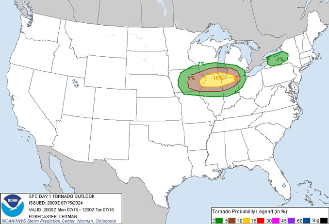
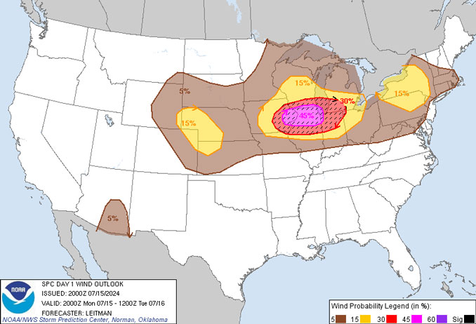
Convective Outlooks from the NOAA National Weather Service Storm Prediction Center have trended upward today to indicate a greater risk of tornadoes and a greater risk of high winds.
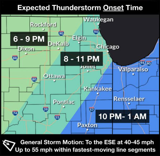
Strong to severe thunderstorms expected late this afternoon into tonight. Locally heavy rainfall possible, which could lead to additional flooding.
Conditions continue to look favorable for a QLCS with damaging winds across much of the CWA this evening. Given combination of extreme instability and moderate shear, cannot rule out some swaths of significant wind damage with gusts over 75mph in spots. In addition, strengthening low level jet this evening should result in favorable environment for QLCS type tornadoes as well.
Flood Watch
National Weather Service Chicago IL
103 PM CDT Mon Jul 15 2024
The National Weather Service in Chicago IL has issued a Flood Watch for the following rivers in Illinois…
Des Plaines River near Des Plaines affecting Northern Cook and Central Cook zones.
Des Plaines River at Lincolnshire affecting Northern Cook and Lake IL zones.
Des Plaines River near Gurnee affecting Lake IL zone.
Des Plaines River near Russell affecting Lake IL zone.
Des Plaines River at Riverside affecting Central Cook zone.
For the Des Plaines River…including Russell, Gurnee, Lincolnshire, Des Plaines…flooding is possible.
Other types of watches and warnings are possible later this evening, including Flash Flood Watch, Severe Thunderstorm Watch, Tornado Watch, Severe Thunderstorm Warning, and Tornado Warning.
PRECAUTIONARY/PREPAREDNESS ACTIONS…
These forecasts are heavily based on forecasted precipitation 24 hours into the future. Changes to the rainfall forecast may cause changes to these river forecasts.
PWAT. Precipitable Water – measure of the depth of liquid water at the surface that would result after precipitating all of the water vapor in a vertical column over a given location, usually extending from the surface to 300 mb.
A quasi-linear convective system (QLCS), is a line of thunderstorms, often forming along or ahead of a cold front. Linear thunderstorm formations often contain heavy precipitation, hail, frequent lightning, strong straight-line winds, and occasionally QLCS tornadoes and waterspouts.
Finally, PWATs over 2″ and very high freezing levels will result in storms being extreme efficient heavy rainfall producers capable of hourly rainfall rates of 2-3″ per hour. Should any “warm air advection” wing type cells develop ahead of the approaching QLCS or upwind propagating storms develop on the tail end of the QLCS, then they would pose a potentially significant flash flood threat. NWS is likely that a (flash) flood watch will eventually be needed for portions of the CWA once the mesoscale evolution of things becomes clearer this afternoon. Of particular concern would be areas near and north of I-88, from the Rockford into the Chicago metro where there have been multiple rounds of heavy rain over the weekend, making them particularly susceptible to flash flooding with any heavy rainfall.
Weather Radar in northeast Illinois was clear, but a complex of thunderstorms have fired up by 4:00 p.m. in northeast Iowa near Cedar Rapids and Waterloo, as expected. Also, a thunderstorm cell in advance of the complex of storms developed about 5:15 p.m. developed just west of Beloit, Wisconsin along the Illinois-Wisconsin State line. The storm that was near Beloit advanced to Harvard, Illinois by 6:15 p.m., and another thunderstorm cell developed over Crystal Lake by 6:10 p.m.
See also Arlingtoncardinal.com/clouds
Tornadic mesovortices all over the place north of Cedar Rapids, IA! pic.twitter.com/iEtjZxyEfC
— Reed Timmer, PhD (@ReedTimmerUSA) July 15, 2024
In an hour or two, each of these storm-scale gust fronts will congeal and the complex will unify behind one dominant mesoscale gust front. The strong wind shear in the ambient environment will maintain vertical convection near the dominant gust front for long-lived wind bag pic.twitter.com/ZLFRImwUEw
— Reed Timmer, PhD (@ReedTimmerUSA) July 15, 2024
Individual supercells will gradually conceal and form a line, with the southern half parallel to the southwesterlies, and will mature over several hours, developing a comma head book end vortex, real inflow jet, and embedded tornadoes from the apex north to the book end pic.twitter.com/3TGztO1jYQ
— Reed Timmer, PhD (@ReedTimmerUSA) July 15, 2024
18Z Day Tornado Forecast (New New 2022 Models) pic.twitter.com/xUWXbct2em
— Nadocast (@nadocast) July 15, 2024
During damaging thunderstorm winds, trees can become dangerous objects. Stay safe by avoiding exterior rooms & windows and by using caution when driving . Prevent damage to your property by trimming loose branches & parking away from trees. https://t.co/fI34LiMepx #ILwx #INwx pic.twitter.com/MPzSgOu9wd
— NWS Chicago (@NWSChicago) July 15, 2024
[4:49 PM CDT 7/15/24] The Storm Prediction Center has upgraded the area to a level 4 out of 5 threat for severe weather tonight for most of the area. The main hazards will be potentially widespread damaging to destructive winds and embedded tornadoes. #ILwx #INwx (1/4) pic.twitter.com/70LE5zba7x
— NWS Chicago (@NWSChicago) July 15, 2024
O’HARE FORECAST …
Monday Night: Showers and thunderstorms, mainly before midnight. Some of the storms could produce heavy rainfall. Low around 73. Southwest wind 5 to 10 mph, with gusts as high as 20 mph. Chance of precipitation is 90%. New rainfall amounts between 1 and 2 inches possible.
Tuesday: A 20 percent chance of showers and thunderstorms before 10am. Partly sunny, with a high near 85. Northwest wind 5 to 10 mph.
Tuesday Night: Partly cloudy, with a low around 67. Northwest wind around 5 mph.
Wednesday: Mostly sunny, with a high near 80. North wind 5 to 10 mph, with gusts as high as 15 mph.
Wednesday Night: Mostly clear, with a low around 62. North northeast wind 5 to 10 mph.
Thursday: Sunny, with a high near 76.
Thursday Night: Clear, with a low around 58.
Friday: Sunny, with a high near 81.
Friday Night: Partly cloudy, with a low around 62.
Saturday: Mostly sunny, with a high near 82.
Saturday Night: Partly cloudy, with a low around 65.
Sunday: Mostly sunny, with a high near 82.
Sunday Night: Partly cloudy, with a low around 64.
Monday: Mostly sunny, with a high near 82.
LAKE TEMPS …
SOUTHERN LAKE MICHIGAN WATER TEMPERATURES
NATIONAL WEATHER SERVICE CHICAGO/ROMEOVILLE IL
920 AM CDT Mon Jul 15 2024
LAKE MICHIGAN WATER TEMPERATURES…
CHICAGO SHORE………..71.
CHICAGO CRIB…………64.
CHICAGO BUOY…………71.
WILMETTE BUOY………..72.
WAUKEGAN BUOY………..70.
WINTHROP HARBOR BUOY….71.
MICHIGAN CITY BUOY……72.
SOUTH MID LAKE BUOY…..69.
CENTRAL MID LAKE BUOY…69.
NORTH MID LAKE BUOY…..68.
&&
july.chicagoweatherstation.com
Chicago Weather Forecast for your MAC/PC/TABLET includes surrounding suburbs.
^^ MOBILE? USE VOICE MIC ^^
facebook …
Please ‘LIKE’ the ‘Arlington Cardinal Page. See all of The Cardinal Facebook fan pages at Arlingtoncardinal.com/about/facebook …
Help fund The Cardinal Arlingtoncardinal.com/sponsor
Area Forecast Discussion
National Weather Service
Chicago/Romeoville, IL
247 PM CDT Mon Jul 15 2024
.KEY MESSAGES…
– Strong to severe thunderstorms expected late this afternoon into tonight. Locally heavy rainfall possible, which could lead to additional flooding.
– Additional thunderstorm chances continue Tuesday, mainly south of I-80/east of I-55.
– Pattern breaks by Wednesday, with dry weather and seasonable temperature and humidity through the weekend.
&&
.MESOSCALE… Issued at 1142 AM CDT Mon Jul 15 2024
Satellite imagery late this morning shows an apparent MCV over western WI moving eastward. This feature seems likely to remain north of our CWA this afternoon and probably a non-factor. Upstream, there is another subtle shortwave apparent over South Dakota which is progged to move east-southeast into northern IA later this afternoon.
At the surface, a very warm and humid air mass blankets the Midwest. There is some evidence of a lingering outflow/moisture discontinuity boundary roughly along the I-80 corridor in our CWA. To the south of this boundary, dewpoints are in the mid-upper 70s with lower 70 dewpoints more common to the north of the boundary. This boundary should continue drifting north and likely dissipate with mid to upper 70 degree dewpoints expected to be fairly common across the area this afternoon.
Morning soundings and SPC objective analysis both show an expansive EML from the Plains east into the mid-Mississippi Valley. These steep lapse rates juxtaposed overtop the very theta-e rich boundary layer will result in extreme instability with 4-5k+ J/kg of MLCAPE this afternoon in an axis from Iowa east into northern Illinois.
As ascent from the South Dakota shortwave trough begins to overtake the extreme instability and weakening inhibition this afternoon, expect explosive severe thunderstorm development over Iowa later this afternoon. Belt of moderate westerly mid-level flow (around 40 kt at 6km) should result in 30-35kt of 0-6km bulk shear. Given the extreme instability, this should allow for supercells with the initial development, but given DCAPE over 1000 J/kg would anticipate an evolution into one or two bowing QLCSs by early evening as the storms approach and move east of the Mississippi River.
Conditions continue to look favorable for a QLCS with damaging winds across much of the CWA this evening. Given combination of extreme instability and moderate shear, cannot rule out some swaths of significant wind damage with gusts over 75mph in spots. In addition, strengthening low level jet this evening should result in favorable environment for QLCS type tornadoes as well.
Finally, PWATs over 2″ and very high freezing levels will result in storms being extreme efficient heavy rainfall producers capable of hourly rainfall rates of 2-3″ per hour. Should any “warm air advection” wing type cells develop ahead of the approaching QLCS or upwind propagating storms develop on the tail end of the QLCS, then they would pose a potentially significant flash flood threat. Think it is likely that a (flash) flood watch will eventually be needed for portions of the CWA once the mesoscale evolution of things becomes clearer this afternoon. Of particular concern would be areas near and north of I-88, from the Rockford into the Chicago metro where there have been multiple rounds of heavy rain over the weekend, making them particularly susceptible to flash flooding with any heavy rainfall.
– Izzi/NWS Chicago
 Amazon Best Sellers in Audible Books