

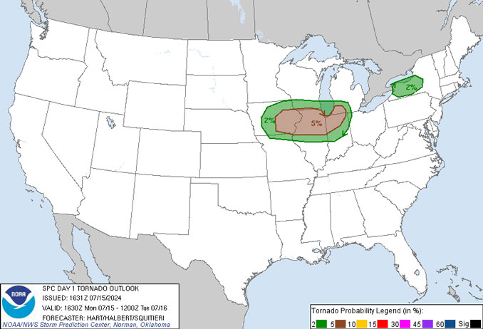
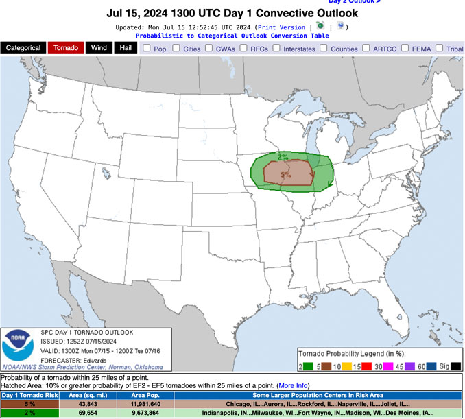
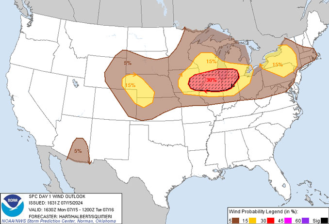
According to meteorologist/storm chaser Reed Timmer, PhD., a major wind bag and even derecho looks possible from central Iowa through northern Illinois, including into Chicago by Monday late evening, with a swath of 75+ mph winds and QLCS tornadoes likely. The initial mode could be supercells in central Iowa, but will quickly congeal into a fast-moving bow echo by the eastern Iowa through Davenport area Monday afternoon.
Monday afternoon, Timmer said that he expects the apex of the bow echo to be just west of Chicago at about 8:00 p.m. The apex of the bow and the area north of the apex is the area most likely to generate tornadoes.
The latest HRRR is indicating a target from southeast Wisconsin to Chicagoland. HRRR is a NOAA real-time 3-km resolution, hourly-updated, cloud-resolving, convection-allowing atmospheric model, initialized by 3km grids with 3km radar assimilation. Radar data is assimilated in the HRRR every 15 min over a 1-h period adding further detail to that provided by the hourly data assimilation from the 13km radar-enhanced
“I am considering a live stream for this textbook ridge rider summer bow echo pattern. Stay tuned!”
— Reed Timmer
A MAJOR WIND BAG and even derecho looks possible from central Iowa through northern Illinois, including into Chicago by Monday late evening, with a swath of 75+ mph winds and QLCS tornadoes likely. The initial mode could be supercells in central Iowa, but will quickly congeal… pic.twitter.com/BOUW9eWdFl
— Reed Timmer, PhD (@ReedTimmerUSA) July 14, 2024
LIVE emergency breakdown of wind bag threat heading for Chicago again this evening with embed tornado threat pic.twitter.com/GzHRUg4NtQ
— Reed Timmer, PhD (@ReedTimmerUSA) July 15, 2024
Meteorologist Ryan Hall also indicated there is a tornado risk, but indicated the highest risk is high winds that may exceed 75 MPH in Chicagoland.
Tornadoes and especially high winds forecast with thunderstorms in Chicago land (RyanHallYall/YouTube). YouTube Tips ⓘ
A quasi-linear convective system (QLCS), is a line of thunderstorms, often forming along or ahead of a cold front. Linear thunderstorm formations often contain heavy precipitation, hail, frequent lightning, strong straight-line winds, and occasionally QLCS tornadoes and waterspouts.
Very strong straight-line winds (70+ MPH) can occur where the linear formation becomes the shape of a bow echo (on radar).
Tornadoes can occur along waves within a Line Echo Wave Pattern (LEWP), where mesoscale low-pressure areas are present. When bow echoes become exceptional large they are known as derochos.
Derechos cause hurricane-force winds, heavy rains, and flash floods. In many cases, convection-induced winds take on the bow echo (backward “C”) form of squall line — the old-fashioned name for QLCS.
Heat-rising, convection-induced winds form beneath an area of diverging upper tropospheric winds, and in a region of both rich low-level moisture and warm-air advection — conditions which we have today. Tropospheric winds are related to the uneven heating of the earth by the sun and large hemispheric areas of the earth where air rises and sinks at different latitudes.
Derechos move rapidly in the direction of movement of their associated storms, like and outflow boundary (gust front), which is a temporary burst of cool air felt ahead of a thunderstorm line before the thunderstorm arrive. Unlike an outflow boundary wind, derecho winds remain sustained for a greater period of time (often increasing in strength after onset), and their velocity can increase to tornado and hurricane-force winds. A derecho-producing convective system can remain active for many hours and, occasionally, over multiple days as it moves across a state or states.
 Amazon Best Sellers in Audible Books