

An uncertain storm-related forecast exists Tuesday into Wednesday with strong to severe storms occurring to the west and southwest of Chicagoland Tuesday during the day. However, strong to severe storms are possible in our area after midnight into Wednesday morning. Large hail, damaging winds, and flash flooding are the main threats.
Additional rounds of thunderstorms are probable Wednesday night through Friday with a continued threat for severe weather and flooding.
Very warm and humid conditions are likely Tuesday through Thursday, but magnitude of the heat potential will depend on storm timing and coverage which remains uncertain in the forecast.
Weather Radar shows strong storms in Iowa moving East-Southeast
See also Arlingtoncardinal.com/clouds
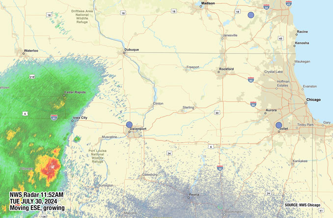
A cluster of thunderstorms is expected to move across central IL this afternoon and evening. A few storms may be strong to severe, but the best severe chances exist south of a Peoria-to-Champaign line. Storms should stay outside of the Chicago metro through this evening. pic.twitter.com/WNwTXmgaFO
— NWS Chicago (@NWSChicago) July 30, 2024
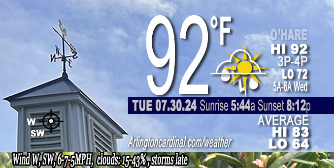
O’HARE FORECAST …
Tuesday Afternoon: Mostly sunny, with a high near 91. Heat index values as high as 95. West northwest wind around 5 mph.
Tonight: A 50 percent chance of showers and thunderstorms, mainly after 1am. Partly cloudy, with a low around 72. Southwest wind around 5 mph becoming south southeast in the evening.
Wednesday: A 40 percent chance of showers and thunderstorms. Partly sunny, with a high near 90. Heat index values as high as 96. West southwest wind 5 to 10 mph.
Wednesday Night: A 50 percent chance of showers and thunderstorms. Partly cloudy, with a low around 74. South wind around 5 mph, with gusts as high as 10 mph.
Thursday: A chance of showers and thunderstorms, then showers likely and possibly a thunderstorm after 1pm. Partly sunny, with a high near 88. West southwest wind 5 to 10 mph, with gusts as high as 15 mph. Chance of precipitation is 60%.
Thursday Night: A 50 percent chance of showers and thunderstorms, mainly before 1am. Mostly cloudy, with a low around 70.
Friday: A 50 percent chance of showers and thunderstorms. Partly sunny, with a high near 83.
Friday Night: Mostly clear, with a low around 70.
Saturday: Sunny, with a high near 88.
Saturday Night: Mostly clear, with a low around 70.
Sunday: Sunny, with a high near 86.
Sunday Night: Partly cloudy, with a low around 67.
Monday: Mostly sunny, with a high near 85.
LAKE TEMPS …
SOUTHERN LAKE MICHIGAN WATER TEMPERATURES
NATIONAL WEATHER SERVICE CHICAGO/ROMEOVILLE IL
947 AM CDT Tue Jul 30 2024
LAKE MICHIGAN WATER TEMPERATURES…
CHICAGO SHORE………..74.
CHICAGO CRIB…………70.
CHICAGO BUOY…………75.
WILMETTE BUOY………..74.
WAUKEGAN BUOY………..74.
WINTHROP HARBOR BUOY….71.
MICHIGAN CITY………..61.
MICHIGAN CITY BUOY……74.
SOUTH MID LAKE BUOY…..74.
CENTRAL MID LAKE BUOY…71.
NORTH MID LAKE BUOY…..70.
&&
july.chicagoweatherstation.com
Chicago Weather Forecast for your MAC/PC/TABLET includes surrounding suburbs.
^^ MOBILE? USE VOICE MIC ^^
facebook …
Please ‘LIKE’ the ‘Arlington Cardinal Page. See all of The Cardinal Facebook fan pages at Arlingtoncardinal.com/about/facebook …
Help fund The Cardinal Arlingtoncardinal.com/sponsor
Area Forecast Discussion National Weather Service Chicago/Romeoville, IL 1120 AM CDT Tue Jul 30 2024
.KEY MESSAGES…
– Large uncertainty forecast today into Wednesday. Potential for strong to severe storms appears to be focused just west and southwest of the forecast area this afternoon but could be close. Damaging winds the primary threat.
– Another period featuring possible strong to severe storms late tonight into Wendesday morning. Large hail, damaging winds, and flash flooding the main threats.
– Additional rounds of thunderstorms probable Wednesday night through Friday with a continued threat for severe weather and flooding.
– At least very warm and humid conditions likely Tuesday through Thursday, but magnitude of the heat potential will depend on storm timing and coverage which remains uncertain.
&&
.UPDATE… Issued at 1120 AM CDT Tue Jul 30 2024
Minor adjustments to going forecast through this evening, mainly to tighten up pop gradient to focus best chances for scattered afternoon and early evening showers and storms mainly west/south of a Rockford to Watseka IL line.
Current surface analysis indicates a nearly stationary frontal boundary from roughly south of Omaha to St. Louis to Evansville line at mid-morning. The Illinois portion of this boundary in particular has been reinforced by outflow along the southern periphery of a small MCS currently exiting IL to the southeast. The frontal zone is progged to lift slowly north as a warm front into this afternoon, though another thunderstorm complex currently over central IA is expected to track along the baroclinic zone and strong instability gradient which may slow/stop the northward advance of the front for a time.
CAM guidance has not been particularly consistent with initializing current activity or progs through this afternoon/early this evening, though earlier runs (12, 13Z) of the HRRR and the 12Z high-res ARW appear to be handling current scenario of IA convection better than most. Although SPC/RA Pmesoanalysis maintains some weak capping in advance of that activity, it appears it should persist following the earlier cluster to the southeast into central IL later this afternoon, perhaps clipping our far southwest counties (especially some of the more stratiform/embedded convection northern periphery). Can`t completely rule out some showers or storms farther north toward KRFD, though the best focus looks to be across our far southwest through this afternoon. With this in mind, have lowered pops farther to the east/northeast especially across the core of the Chicago metro and northern suburbs, where threat of showers/storms looks minimal. May then see a lull across the area early this evening, before renewed MCS development becomes more likely across IA and eventually into northern IL late tonight. NAM nest forecast of MN/northwest WI convection developing southeast into northern IL early-mid evening appears to be fairly aggressive with responsible short wave tracking north of our area, but will keep an eye on trends to our northwest this afternoon.
Otherwise, going forecast appears on track through this evening, with no changes significant changes made other than po Ptrends outlined above.
– Ratzer/NWS
&&
.DISCUSSION… Issued at 209 AM CDT Tue Jul 30 2024
Through Wednesday:
A complex and challenging forecast period awaits in the short term as a conditionally highly unstable airmass meanders northward along the northern periphery of an expansive 596-600 dm high pressure center. Numerous perturbations–either synoptic in nature of born out of remnant convective episodes–will traverse the Great Plains and Upper Midwest within broad and increasingly quick northwest flow aloft. These scenarios feature unusually high degrees of forecast uncertainty as effects of improperly modeled thunderstorm complexes have significant cascading downstream effects on subsequent outcomes. One of the classic modeling conundrums relates to ongoing MCSs which have well-developed/deep cold pools that are not analyzed correctly in model background fields. In the case of the HRRR, no amount of radar-assimilated storms can re-produce the correct cold pool depth/orientation, resulting in storms either dissipating in an otherwise favorable environment, or moving in an incorrect direction. The ongoing complex across NW Iowa is a great example of this, with runs up to this point doing a generally poor job resolving the MCS`s strength and longevity. CAM-watching in these setups may cause heartburn.
For today, relying more on conceptual models to guide the forecast. With a mature, severe, forward propagating MCS in progress, the orientation of the 925-850 mb theta-e axis should serve as the general “MCS highway” this morning, and based on recent objective analysis, this stretches from roughly central Iowa, southeast towards the Bloomington/Champaign, IL area. Dee Player shear vectors similarly begin to point more southeasterly with eastward extent, so the expectation is for this complex to begin to turn more southeastward with time–and we`re already seeing this occurring. Deep shear also diminishes a bit farther east, which all suggests this feature diving just south of our forecast area and gradually exhausting an outflow boundary. It`s plausible that surging outflow serves as a local focus to po Psome isolated to scattered showers and storms this morning in our area (would be after about 9 am in our far far southwest), but with the main instability reservoir still to our south, we`d struggle to manage anything organized.
For this afternoon`s part of the forecast, attention is focused on what`s ongoing across the Dakotas and Minnesota, where an MCV embedded within a synoptic shortwave is pinwheeling eastward. To the south of this feature, a west-east oriented band of expanding cloud cover near 500-600 mb is indicative of some upper-level ascent spreading eastward. An intensifying LLJ is also starting to impinge on a remnant moist 925-850 mb moist axis arcing from near a Sioux City to Rapid City line where additional elevated convection has been trying to establish recently. These multiple forcing mechanisms *may* help develop another convective complex through this morning. If this materializes, it`d be at a slightly higher latitude than the ongoing system, suggesting a somewhat increased chance of clipping or getting into parts of the forecast area this afternoon. Have gently increased PoPs a smidge for the roughly west/southwest half of the area (roughly SW of a Beloit to Rensselaer line) as a result, but uncertainty in this evolution is still too high to justify anything more than mid-grade “chance” PoPs. Deep layer shear is not forecast to be as significant in our area compared to farther south, but sufficient (35-40 knots) within the very moist/unstable environment to facilitate a severe threat, mainly from damaging winds. This is all conditional on an complex developing, maturing, and subsequently sustaining eastward into Iowa.
For tonight, any earlier activity should migrate south of the area. During this time, the steepest portion of the EML plume will begin advecting into our region, with 700-500 mb lapse rates nearing 8 C/km advertised across the guidance suite. Of concern is that a notable LLJ will nocturnally strengthen at the base of the EML, with the northeastern terminus forecast to build into northeast Iowa. These are scenarios in which we have to tread carefully, as just slight increases in dewpoints/rh off the surface can turn a dry forecast (in which a model fails to “convect”) into one with robust strong-severe storms. Am somewhat concerned the late overnight period into Wednesday morning could be one of these scenarios, but comes down entirely to how the moisture fields in the critical 925-800 mb layer evolve, and where precisely this axis sets up. In many cases, it seems like hires guidance sets these axes up too far to the south and west initially. Several pieces of guidance have hinted at elevated convection erupting in this regime, and even if they do so inconsistently, it`s a signal the atmosphere is on the verge of saturating sufficiently for elevated parcels to breach their LFCs. If storms develop, a NW-SE orientation could spell a training scenario with a flash flood threat, in addition to the potential for severe weather. The main time frame of interest is very late overnight through about mid-morning Wednesday. Again, on the table is an entirely dry outcome, but the potential for at least some convection currently looks more probable, with high- end chance PoPs smeared across the entire forecast area.
Wednesday`s forecast evolution hinges to a large degree on how things play on Tuesday night. If convection is widespread and lingers deep into the morning the effective warm front may get shoved so far south, that things remain largely dry here. Additionally, guidance seems to have trended a bit slower with the next shortwave trough which may end up temporarily placing us in a briefly more subsident regime on Wednesday. Just way too many moving parts to do anything more than continue a mention of 20-30 percent PoPs during the afternoon.
Regarding the heat: humidity will build notably today with dewpoints forecast to remain steady or slowly rise with mixing. This should yield peak heat indices in the upper 90s, perhaps locally nearing 100. On Wednesday, thicknesses and 925 mb temperatures would support highs in the mid 90s. With dewpoints in the mid 70s, peak heat indices would be near Heat Advisory criteria (105+). However, with the potential for morning storms, or additional afternoon storms, a “cooler” outcome is certainly in the cards. We`ll continue to play any heat headline decisions day-by-day as a result.
– Carlaw/NWS
Wednesday Night through Monday:
Primary forecast concerns are thunderstorm chances/timing thru Friday and high temps/heat index values Thursday.
As often is the case in patterns like these, confidence decreases further in time with convective trends as they are frequently dependent on previous thunderstorm timing/location. If Wednesday afternoon/evening ends up being mainly dry, then there may be higher confidence for another round of thunderstorms late Wednesday night into Thursday morning in or nearby the local area and if these materialize, they will likely be capable of very heavy rain with a localized flooding threat.
An upper level low is then expected to move across the region Thursday night into Friday. Its possible Thursday afternoon may be a lull for precip but blended pops are in the likely range. There will likely be another period of showers with possible thunder as the upper low moves across the area but low confidence for exact timing. There will remain a chance of showers and thunderstorms Friday as the upper low departs and perhaps a better chance across the southeast half of the area.
While a dry period is expected Friday night through early next week there remains uncertainty with guidance now hinting at precip chances Sunday night/Monday. This time period has been dry for the past few days and maintained dry blended pops but this time period will need to be monitored.
As for temperatures, there is quite a bit of uncertainty for highs on Thursday and currently have upper 80s for highs most areas with dewpoints in the mid/upper 70s. Thus it will be very humid Thursday, but precip in the morning and possible preci Pin the afternoon lower confidence for high temps. This combination would yield heat index values in the mid 90s north to around 100 south. If more sunshine develops and highs can reach into the lower 90s, heat index values will be higher and possibly nearing advisory levels along/south of I-80.
Dewpoints will lower some after Thursday, but still in the upper 60s/lower 70s into early next week. Clouds and precip may keep temps in the lower/mid 80s Friday, but highs may make a run at 90 on Saturday. cms
&&
.AVIATION /12Z TAFS THROUGH 18Z WEDNESDAY/… Issued at 636 AM CDT Tue Jul 30 2024
Forecast concerns include…
Patchy fog early this morning. Lake breeze this afternoon. Chance of thunderstorms tonight/Wednesday morning.
Patchy fog outside of the Chicago metro and Chicago terminals will dissipate over the next hour or so.
Westerly winds generally under 10kts are expected today, possibly turning more southwesterly. These speeds are expected to be light enough to allow a lake breeze to develop and move through MDW/GYY. Medium confidence the lake breeze will make it to ORD, or possibly stall near ORD in the late afternoon. Trends will still need to be monitored and changes with later forecasts are possible. Winds will turn light south/southwest this evening.
There remains a chance for thunderstorms this afternoon, possibly into the early evening southwest of the Chicago terminals and confidence is increasing for dry conditions at the Chicago terminals this afternoon. RFD would have a better, though still low chance for thunderstorms this afternoon but have maintained a dry forecast there as well.
The best chance of thunderstorms remains late tonight into Wednesday morning. Confidence remains too low to include mention at the Chicago terminals. Have added prob mention for thunder at RFD for the overnight hours and some thunder mention may eventually be needed at the rest of the terminals. cms
&&
.LOT WATCHES/WARNINGS/ADVISORIES… IL…None. IN…None. LM…None.
&&
 Amazon Best Sellers in Audible Books