

The remnants low pressure and precipitation of Hurricane Beryl will move through northern Illinois Tuesday afternoon and Wednesday morning with a threat for gusty winds and flooding, particularly along and east-southeast of the I-55 corridor. Arlington Heights and northwest Cook County is at the northern edge of a Flood Watch area in effect from July 9, 02:00 PM CDT until July 10, 01:00 PM CDT.
A widespread flood/flash flood threat is not likely to develop today, but isolated rainfall amounts over 3-4 inches are certainly plausible, according to the National Weather Service Chicago. An occasional lightning strike is possible today, but widespread electrification with lightning appears unlikely, according to the NWS Chicago.
Weather Radar (LIVE) shows a very large area of precipitation moving slowly north with the northern edge of significant precipitation along a line from Peoria, Illinois to the southern tip of Lake Michigan at 10:50 a.m.
See also Arlingtoncardinal.com/clouds
Heavy to torrential rainfall will spread northward across northern IL and northwest IN through the rest of today. Localized instances of flooding are expected, especially in low-lying and poor drainage areas. Remember if you encounter floodwater, Turn Around, Don’t Drown!! pic.twitter.com/qBkplwAOXQ
— NWS Chicago (@NWSChicago) July 9, 2024
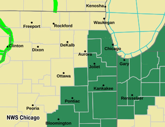
A flood watch is in effect along and east-southeast of the I-55 corridor from this afternoon through Wednesday morning due to the threat of very heavy rainfall from the remnants of Beryl. #ILwx #INwx pic.twitter.com/QJ9kkhn5DT
— NWS Chicago (@NWSChicago) July 9, 2024
O’HARE FORECAST …
Tuesday: A slight chance of showers before 1pm, then a chance of showers and thunderstorms between 1pm and 2pm, then showers likely and possibly a thunderstorm after 2pm. Cloudy, with a high near 83. Light east wind increasing to 5 to 10 mph in the afternoon. Chance of precipitation is 70%. New rainfall amounts between a tenth and quarter of an inch, except higher amounts possible in thunderstorms.
Tuesday Night: Showers and possibly a thunderstorm. Low around 66. East wind 5 to 15 mph becoming north after midnight. Winds could gust as high as 25 mph. Chance of precipitation is 100%. New rainfall amounts between three quarters and one inch possible.
Wednesday: Showers likely, with thunderstorms also possible after 4pm. Cloudy, then gradually becoming mostly sunny, with a high near 78. North wind around 10 mph, with gusts as high as 25 mph. Chance of precipitation is 60%. New rainfall amounts between a quarter and half of an inch possible.
Wednesday Night: A slight chance of thunderstorms before 7pm. Partly cloudy, with a low around 64. North northeast wind 5 to 10 mph. Chance of precipitation is 10%.
Thursday: A 20 percent chance of showers and thunderstorms after 1pm. Mostly sunny, with a high near 81. North northwest wind around 5 mph becoming east northeast in the afternoon. Winds could gust as high as 10 mph.
Thursday Night: Partly cloudy, with a low around 65.
Friday: A 20 percent chance of showers and thunderstorms after 1pm. Mostly sunny, with a high near 86.
Friday Night: Mostly clear, with a low around 68.
Saturday: Mostly sunny, with a high near 88.
Saturday Night: Partly cloudy, with a low around 72.
Sunday: Sunny, with a high near 92.
Sunday Night: Mostly clear, with a low around 76.
Monday: Mostly sunny, with a high near 94.
LAKE TEMPS …
SOUTHERN LAKE MICHIGAN WATER TEMPERATURES
NATIONAL WEATHER SERVICE CHICAGO/ROMEOVILLE IL
924 AM CDT Tue Jul 9 2024
LAKE MICHIGAN WATER TEMPERATURES…
CHICAGO SHORE………..69.
CHICAGO CRIB…………68.
CHICAGO BUOY…………71.
WILMETTE BUOY………..70.
WAUKEGAN BUOY………..69.
WINTHROP HARBOR BUOY….60.
MICHIGAN CITY BUOY……70.
SOUTH MID LAKE BUOY…..69.
CENTRAL MID LAKE BUOY…65.
NORTH MID LAKE BUOY…..62.
july.chicagoweatherstation.com
Chicago Weather Forecast for your MAC/PC/TABLET includes surrounding suburbs.
^^ MOBILE? USE VOICE MIC ^^
facebook …
Please ‘LIKE’ the ‘Arlington Cardinal Page. See all of The Cardinal Facebook fan pages at Arlingtoncardinal.com/about/facebook …
Help fund The Cardinal Arlingtoncardinal.com/sponsor
Area Forecast Discussion
National Weather Service
Chicago/Romeoville, IL
1030 AM CDT Tue Jul 9 2024
.KEY MESSAGES…
– The remnants of Hurricane Beryl will move through the general region later today into early Wednesday with a threat for gusty winds and flooding, particularly along and east-southeast of the I-55 corridor.
– Isolated to scattered showers and storms may continue Thursday and Friday, followed by increasing temperatures and humidity levels this weekend.
&&
.UPDATE… Issued at 1030 AM CDT Tue Jul 9 2024
All eyes are on the remnants of tropical system Beryl with the center of low pressure now pinwheeling steadily northeastward across Arkansas. Ahead of it, numerous diffuse boundaries are analyzed across our region, including a wavy quasistationary front which stretches from near Valparaiso to Pontiac to Quincy, and another one across SE Wisconsin and far northwest Illinois. Aloft, additional confluence axes are noted in the 850-700 mb layer which are forecast to drift northward towards the I-80 corridor through the afternoon. Finally, a lake breeze will also develop across northeast Illinois.
A very moist airmass has pushed into the area, with PWATs near 2 inches on latest objective analyses and the 12z Lincoln, IL sounding, with a classic “tropical look” with deep saturation and a relatively warm column characterized by near moist- adiabatic lapse rates.
Arcs of slow-moving (nearly stationary) showers and the occasional thunderstorm have developed along one of the aforementioned surface boundaries in the vicinity of the Kankakee River. These exhibit classic low-echo centroids, with pretty much all of the 45+ dBZ returns confined below the freezing level. We`ve noted some localized rates nearing 1-2 inches per hour with these cells on several personal weather stations.
While this set-up may not fit all of the definitions of a Predecessor Rain Event, the dynamics/driving factors are the same, with augmentations to the anticyclonically-arcing upper jet from the incoming post-tropical low leading to an enhanced reservoir of divergence aloft. As this enhanced lift interacts with low-level boundaries, slow-moving showers/storms result.
Going forward, the main concern today will be on highly localized corridors of heavy/torrential rainfall leading to instances of flooding which will be tied to the aforementioned boundaries. As such, we`re not concerned with a widespread flood/flash flood threat through the balance of the day today, but isolated rainfall amounts over 3-4 inches are certainly plausible. While an occasional lightning strike is possible today, widespread electrification appears unlikely given the moist adiabatic profiles.
We`ll continue to assess incoming guidance as it relates to the heavy rain and more widespread flood threat tonight with the afternoon forecast package. There are also some hints in hires output that winds may need to be nudged upwards, as well.
— NWS/Carlaw
&&
.DISCUSSION… Issued at 332 AM CDT Tue Jul 9 2024
Through Wednesday night:
The main focus continues to revolve around the increasing threat for periods of very heavy rainfall and strong winds later today into Wednesday morning as the remnants of Beryl move into the Lower Great Lakes.
As of this writing, the center of Tropical Depression Beryl was located over southeastern AR, and it`s movement is north-northeast just under 20 mph. Model and ensemble guidance have been coming into better agreement with the track of Beryl later today into Wednesday as it begins its post tropical transition. While this is the case, modest ensemble spread is still noted tonight into Wednesday morning as the system tracks northeast from just southeast of St Louis to near Fort Wane, IN. While these differences could still play a role in the exact placement of the heaviest rainfall axis, confidence continues to increase that this axis will fall roughly along and east-southeast of the I-55 corridor. For this reason, we have opted to issue a Flood Watch from late this afternoon through Wednesday morning for this general area. We also opted to add Cook county into this watch, though it is possible that the far southern portion of the county (from the city south) experiences the highest rainfall amounts (and hence the highest threat for flooding.
As Beryl approaches into the area through the day, it will began to lose it`s tropical characteristics while phasing with an upper-level trough approaching the Great Lakes from the northwest. This will set the stage for a notable increase in synoptic-scale forcing as a coupled upper-level jet structure sets up overtop of a strengthening band of low to mid-level frontogenesis oriented roughly along the I-55 corridor. Strong and deep forced ascent within this region will act upon tropical-like moisture (PWATs approaching 2.25″), resulting in very efficient warm-rain processes. The net result of this will be a band of very heavy rainfall, which should peak in intensity tonight in and even near the watch area. Rain rates of 1″+ per hour will be likely within this band, and this could result in total rainfall amounts in excess of 5 inches across part of the watch area by late Wednesday morning. Rainfall amounts of this magnitude would support significant rises and flooding of small streams and rivers, and possibly even some instances of flash flooding.
In addition to the heavy rainfall, a period of strong gusty northeasterly to northerly winds are expected across eastern IL into northwestern IN tonight into early Wednesday morning as the center of circulation shifts into northeastern IN. The strong gradient along the northwestern periphery of the system will support gusts up to 40 mph. This will result in building waves on southern Lake Michigan, and the onset of dangerous to even life threatening swimming conditions along the southern shores of the lake tonight through Wednesday. A small craft advisory and beach hazard statement will be needed as a result.
The remnants of Beryl will begin to exit our area into the afternoon on Wednesday. While this will end the the heavy rain threat, the threat for a few afternoon showers, and possibly even a few thunderstorms will continue as a second mid-level impulse begins to shift into the Midwest late in the day.
— NWS/KJB
Thursday through Monday:
The thinking during the extend period has not changed. Reference the most recent discussion below.
Thursday and Friday, upper-level troughing will remain overhead and provide the means for isolated to scattered diurnal showers and thunderstorms. Looking toward the weekend and beyond, ensemble model guidance supports the development of an upper-level ridge across the central United States with the “downward” branch oriented into the Great Lakes. Such a pattern will support rising temperatures and humidity levels, as well as chances for episodic thunderstorm clusters.
— NWS/Borchardt
 Amazon Best Sellers in Audible Books