Above Normal Temps Could Continue Through Spring 2024

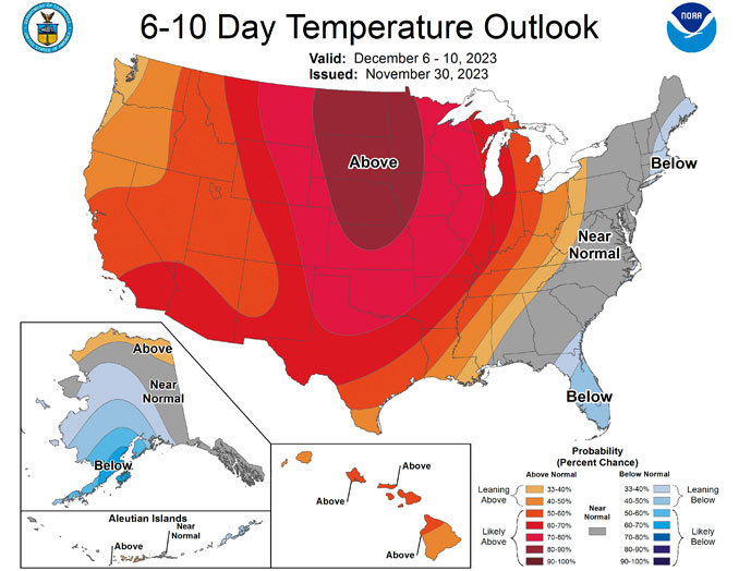
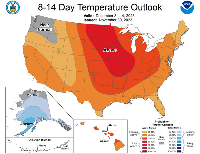
According to the National Weather Service Office in Chicago, strong indications exist that temperatures through the first half of December 2023 will be above average. Average highs are mid-upper 30s, and average lows are historically in the low-mid 20s. According to the National Weather Service Climate Prediction Center (NWSCPC), most of Chicagoland (west and north) has a 70% to 80% probability of above normal temperatures. The City of Chicago and northwest Indiana has a 60% to 70% probability of above normal temperatures for the period from December 6, 2023 to December 10, 2023.
This doesn’t necessarily mean everyday will be mild, but overall the period should be mild, according to the National Weather Service Office in Chicago.

El Nino in 2023 is in place heading into winter for the first time in four years, driving the outlook for warmer-than-average temperatures for the northern tier of the continental United States, according to NOAA’s U.S. Winter Outlook that was released October 19, 2023 by the Climate Prediction Center — a division of the National Weather Service.
The NWSCPC announced on November 9, 2023 that El Niño is anticipated to continue through the Northern Hemisphere spring (with a 62% chance during April-June 2024).
Based on forecasts in early, there is a greater than 55% chance of at least a “strong” El Niño (≥ 1.5°C in Niño-3.4 for a seasonal average) persisting through January-March 2024. There is a 35% chance of this event becoming “historically strong” (≥ 2.0°C) for the November-January season.
A 1.5°C difference from 0°C to 1.5°C would be a difference of about 32°F to 34.7° or an increase of about 2.7°F.
A 2.0°C difference from 0°C to 2.0°C would be a difference of about 32°F to 35.6° or an increase of about 3.6°F.
“These outlooks provide critical guidance on the upcoming season for many industries and sectors of our economy, from energy producers to commodities markets to agricultural interests to tourism,” said Sarah Kapnick, Ph.D., NOAA chief scientist. “With a strengthening El Nino and more potential climate extremes in an already record-breaking year, we’re lucky to have scientists like those at the Climate Prediction Center helping to build a Weather and Climate-Ready Nation by providing critical operational seasonal climate predictions.”
From December through February, NOAA predicts wetter-than-average conditions for northern Alaska, portions of the West, the southern Plains, Southeast, Gulf Coast and lower mid-Atlantic and drier-than-average conditions across the northern tier of the U.S., especially in the northern Rockies and High Plains and near the Great Lakes.
“An enhanced southern jet stream and associated moisture often present during strong El Nino events supports high odds for above-average precipitation for the Gulf Coast, lower Mississippi Valley and Southeast states this winter,” said Jon Gottschalck, chief of the Operational Prediction Branch of the Climate Prediction Center.
NOAA forecasters, in collaboration with the National Integrated Drought Information System (NIDIS), continue to monitor extreme, ongoing drought conditions that have persisted through the southern and central U.S. and worsening drought in Hawaii.
“According to the Oct. 17 U.S. Drought Monitor, a third of the country, including Puerto Rico, is in drought,” said Brad Pugh, operational drought lead with NOAA’s Climate Prediction Center. “During late October, heavy precipitation is likely to result in drought improvement for the central U.S.
El Nino with its enhanced precipitation is expected to provide drought relief to the southern U.S. during the next few months.”
^^ MOBILE? USE VOICE MIC ^^
facebook …
Please ‘LIKE’ the ‘Arlington Cardinal Page. See all of The Cardinal Facebook fan pages at Arlingtoncardinal.com/about/facebook …
Help fund The Cardinal Arlingtoncardinal.com/sponsor
20240105-1435future
THANKS FOR READING CARDINAL NEWS


 Amazon Best Sellers in Audible Books