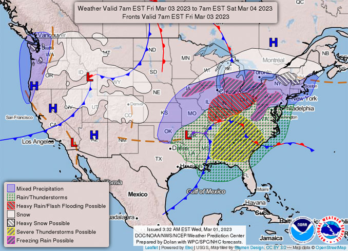
A weather system that could possibly dump deep, wet snow on Chicagoland continues to advance to Chicagoland Friday, but the long-range forecasted tracks in weather models has wobbled and diminished total snow accumulation outlooks. The confidence in snow accumulation forecasting is elusive.
The deepest snow track with the ECMWF model remains across far west suburbs, northwest suburbs, McHenry County and western Lake County; however, accumulations of 8 and 9 inches have been lowered to about 5 to 8 inches. The forecast deep track runs approximately from Galesburg, Illinois to Antioch, Illinois.
The deepest snow track with the GFS model is located from southwest of Kankakee, then across Bourbonnais, Kankakakee, Momence and into Indiana with accumulations of 6 and almost 9 inches.
[4:30 AM 3/1] The potential for accumulating snow and wintry impacts remains for Friday, but uncertainty remains unusually high. Be sure to continue to check back for updates as we better refine Friday’s forecast. #ILwx #INwx pic.twitter.com/6UCR5fQbqL
— NWS Chicago (@NWSChicago) March 1, 2023
The northern jet stream is forecast to plunge a Low pressure core into the desert southwest late Wednesday night into Thursday morning. This system wastes no time hanging around, as the jet is forecast to move east into Texas. As this system moves into the southern Plains, it is forecast to become excessively moisture-laden from the warmer waters of the Gulf of Mexico. This system is forecast to lift north-northeast, as High pressure ridging builds stronger over the Bahamas, and pushes the system up the Mississippi River Valley. The system is forecast to arrive in the Ohio River Valley towards central Illinois late in the day Friday, and continue to shift to the northeast United States late Friday and Saturday.
There is low confidence for the location of the deepest snow track — or even the appearance of snow in some areas of Chicagoland. However, NWS Chicago expects a widespread impactful event late Thursday and Friday, whether that be additional heavy rainfall, widespread snow accumulations, or a mixed precipitation event with snow and rain splitting the Chicagoland region.
In general the ECMWF model has a north side track and the GFS model has a south side track. Then, to make the outlook more complicated, either of the these model’s tracks could wobble more north or more south.
If the northern ECMWF model track holds true, there will be the potential for deep snow across far north and northwest Chicagoland, mixed precipitation across mid-Chicagoland, and heavy rainfall and the potential for isolated thunderstorms across far southeast Chicagoland.
If the southern track of the GFS model, which is in closer agreement with the Canadian model, holds true; then there will be more widespread, but less deep snowfall coverage, over Chicagoland with mixed precipitation slated more across the far southeast. If the GFS model tracks further north, then deep snow across Kankakee, Bourbonnais, and Momence is more likely.
NWS Chicago on Wednesday morning did not mention the wet snow potential with snow ratios of less than 9:1 (9 inches of snow holding 1 inch of water), as was mentioned Tuesday. The snow is still expected to be very wet and heavy.
With the worst case scenario ECMWF model, the south margin consisting of 6 inches to 7 inches is taking shape around Schaumburg to southern Arlington Heights to Vernon Hills. The north margin from 6 inches to 7 inches is indicated around Poplar Grove, Harvard, and Marengo.
In the worst case scenario, the modeling for the 10-mile long Arlington Heights community is shaping up to produce a wet snow dump of about 6.4 inches near Lake Cook Road, 6.4 inches near Palatine Road, and 6.1 inches near Algonquin Road.
Also in the worst case scenario, about 8 inches of west snow will accumulate in McHenry, Fox Lake, Johnsburg, Prairie Grove, Spring Grove, Wonder Lake, and Volo.
If the ECMWF track is wrong and goes north, we will be facing a threat of heavy rain, and possibly snow accumulation of less than 2 inches.
If the GFS model track goes south, the deepest snow will be in the south Chicago suburbs and Indiana.
If the GFS model holds true, it is possible Arlington Heights and nearby communities will only see an accumulation of about 1.5 inch with barely any snow or slush accumulating on streets and driveways. Also, communities of McHenry, Fox Lake, Johnsburg, Prairie Grove, Spring Grove, Wonder Lake, and Volo would barely see snow, or might get no snow at all with a south track GFS model holding true.
As for temperatures over the period, cooler conditions settle in beginning Thursday behind the frontal passage, and linger through
the weekend. Arlington Heights and surrounding communities still might reach a high of 37°F on Friday during a mixed snowfall and rainfall period. Over one inch of rain could accumulate while 1.5 inches of snow accumulates Friday in Arlington Heights.
^^ MOBILE? USE VOICE MIC ^^
facebook …
Please ‘LIKE’ the ‘Arlington Cardinal Page. See all of The Cardinal Facebook fan pages at Arlingtoncardinal.com/about/facebook …
Help fund The Cardinal Arlingtoncardinal.com/sponsor
20240105-1435future
THANKS FOR READING CARDINAL NEWS


 Amazon Best Sellers in Audible Books