Ryan Hall provides live coverage of Hurricane Ian on Wednesday, September 28, 2022. YouTube Tips ⓘ
UPDATE: Live coverage continues Wednesday, September 28, 2022 as Hurricane Ian is expected to make landfall on the west coast of Florida near Fort Myers.
Ryan Hall provides live coverage of Hurricane Ian. YouTube Tips ⓘ
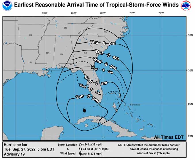
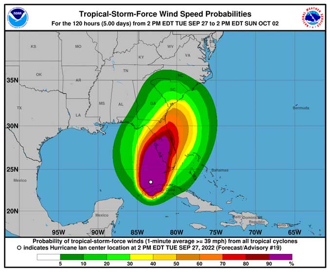
Multiple tornadoes have been reported in the Miami area on the east coast of Florida as Hurricane Ian approaches for a landfall on the west coast of Florida. Tropical Storm Force Winds have hit southwest Florida near Naples at about 8:00 p.m. Tuesday. Tropical Storm Force Winds are expected to hit the Tampa Bay area about 2:00 a.m. Wednesday, and Orlando and Lakeland about 8:00 a.m. Wednesday.


Hurricane Ian is the ninth named storm for Fall 2022, and is the fourth hurricane and second major hurricane of the 2022 Atlantic hurricane season. Ian originated from a tropical wave that was located east of the Windward Islands, just north of Venezuela on September 19, 2022 (discovered by the National Hurricane Center).
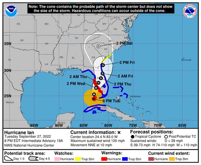
According to the NWS Tampa Bay Area, Florida, Hurricane Ian continued to travel north over the southeastern Gulf of Mexico. Outer rainbands continue to bring showers and a few embedded storms across much of the area this afternoon. Ian will continue to lift north, then turn more northeast as it parallels the western Florida coastline, with rainbands continuing to spread northward over the area through the night. Impacts will begin to be felt starting during the overnight hours, with impacts continuing through Thursday and improving Friday.

D: Tropical Depression – wind speed less than 39 MPH
S: Tropical Storm – wind speed between 39 MPH and 73 MPH
H: Hurricane – wind speed between 74 MPH and 110 MPH
M: Major Hurricane – wind speed greater than 110 MPH
^^ MOBILE? USE VOICE MIC ^^
facebook …
Please ‘LIKE’ the ‘Arlington Cardinal Page. See all of The Cardinal Facebook fan pages at Arlingtoncardinal.com/about/facebook …
Help fund The Cardinal Arlingtoncardinal.com/sponsor
20240105-1435future
THANKS FOR READING CARDINAL NEWS
Hurricane Ian History
Hurricane Ian continues to strengthening after making landfall in Western Cuba, and advancing toward Florida. Two days later, the wave moved into the Caribbean Sea, where it brought winds and heavy rain to ABC islands, Trinidad and Tobago, and the northern coasts of Venezuela and Colombia; it then showed signs of development of a tropical depression later that day, as its convection increased and became more focused. Later it intensified into a hurricane as it neared the Cayman Islands, before rapidly intensifying to a Category 2 Hurricane North West of the Cayman Islands, then as a high-end Category 3 hurricane as it made landfall in western Cuba. Hurricane Ian weakened slightly over land in Cuba, but restrengthened once it moved off of Cuba in the southeastern Gulf of Mexico.
Saffir–Simpson scale
Category 1
74–95 mph
Category 2
96–110 mph
Category 3
111–129 mph
Category 4
130–156 mph
Category 5
Greater than 157 MPH
