NWS FORECAST: KORD | KPWK | Forecast Graph O’Hare
***********
O’HARE FORECAST …
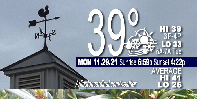
Today: Scattered rain and snow showers before 3pm, then a slight chance of rain showers between 3pm and 5pm. Cloudy, with a high near 39. South wind 10 to 15 mph, with gusts as high as 25 mph. Chance of precipitation is 40%.
Tonight: Partly cloudy, with a low around 33. South wind around 10 mph becoming northwest after midnight. Winds could gust as high as 15 mph.
Tuesday: Mostly sunny, with a high near 45. West wind around 10 mph.
Tuesday Night: Mostly cloudy, with a low around 30. West northwest wind 5 to 10 mph becoming south southwest after midnight.
Wednesday: A slight chance of rain and snow before 10am, then a slight chance of rain between 10am and noon. Partly sunny, with a high near 49. Southwest wind 5 to 15 mph, with gusts as high as 25 mph. Chance of precipitation is 20%.
WEATHER DETAILS
Another shortwave in the seemingly endless parade of weak west- northwest flow shortwaves could bring a brief shot of some rain or snow showers this afternoon. Vorticity max over southern Manitoba early this morning will track southeast into the upper Mississippi Valley and upper Great Lakes regions this afternoon, then continue quickly eastward toward the eastern lakes region tonight.
A north-south oriented band of strong warm air advection is forecasted to sweep across the area later this morning into the afternoon. This axis of Warm Air Advection (WAA) is depicted very nicely by the strong/very strong pressure advection on the 285K-305K isentropic surfaces. Antecedent air mass across the region is quite dry from the surface up to a bit above 700mb, so some portion (maybe most) of the ascent associated with this band of strong warm air advection will be used to saturate the column from the top down. It is quite possible that the dry air will win out and we not see any precipitation in the area today or just sprinkles/flurries. However, given the magnitude of the forcing, the associated transient but fairly strong 800-700mb f-gen band, presence of strongly negative saturated Equivalent Potential Vorticity (EPV), and tendency for WAA precipitation events to over-perform the NWS Chicago Office did raise Probability of Precipitation (pops) a bit and changed to coverage wording (scattered instead of chance) for the precipitation.
Precipitation type will be a bit tricky as strong warm air advection and surface temps before the precipitation that are solidly above freezing would suggest mainly rain showers/sprinkles. However, evaporative cooling owing to the dry air mass could work to offset the warm air advection and result in precipitation falling more as snow showers. In addition, it isn’t uncommon to see a brief period of ice pellets at the onset of the precipitation in these type of top-down saturation events. Given the uncertainty, the course of least regret looks to be including rain or snow showers in the forecast this afternoon. At this point, the thinking is that temps will be just barely on the warm side, and precipitation not quite heavy enough for any snow accumulation.
In the wake of this wave, look for skies to clear out tonight and remain partly to mostly sunny tomorrow with milder temperatures expected.
— NWS Chicago with CARDINAL NEWS edits
DEW/FROST
No dew or frost observed with Dew Point Depression readings of 13 to 14°F and mostly cloudy skies.
RADAR/SATELLITE
Weather Radar shows precipitation moving northwest to southeast over northern Illinois at 10:00 a.m. while no precipitation was hitting the ground.
Arlingtoncardinal.com/clouds | Arlingtoncardinal.com/temps
**********
WEATHER OBSERVATIONS
NOTE: As of Nov. 23, 2021, National Weather Service feeds with hourly observations are broken. New hourly observations are stalled. A link in the most recent tweet, refers to an updated table with hourly observations with the correct data.
NWS CHICAGO
TRAFFIC
Chicagoland Traffic on Twitter
Northwest Suburbs
Google Traffic Layer | waze map
Arlington Heights North
Google Traffic Layer | waze map
Arlington Heights South
Google Traffic Layer | waze map
Chicagoland
Google Traffic Layer | waze map
Cook County
Google Traffic Layer | waze map
Lake County
Google Traffic Layer | waze map
McHenry County
Google Traffic Layer | waze map
DuPage County
Google Traffic Layer | waze map
Kane County
Google Traffic Layer | waze map
Will County
Google Traffic Layer | waze map
Flights
flightradar24 DIRECT …
O’Hare | Midway | Chicago Executive | DuPage
^^ MOBILE? USE VOICE MIC ^^
facebook …
Please ‘LIKE’ the ‘Arlington Cardinal Page. See all of The Cardinal Facebook fan pages at Arlingtoncardinal.com/about/facebook …
Help fund The Cardinal Arlingtoncardinal.com/sponsor
20240105-1435future
CBS THIS MORNING …
Latest videos from CBSThisMorning.
Youtube.com/CBSThisMorning/videos
TODAY NBC …
Latest videos from TODAYNBC.
GMA …
Latest video from GMA.
Second to latest video from GMA.
Much of the information in this article consists of material from the National Weather Service, which is in the public domain. As required by 17 U.S.C. § 403, third parties producing copyrighted works consisting predominantly of the material appearing in NWS Web pages must provide notice with such work(s) identifying the NWS material incorporated and stating that such material is not subject to copyright protection.
