LIVE: Tracking Hurricane Ida with satellite imaging and an updated forecast cone from NBC News. YouTube Tips ⓘ
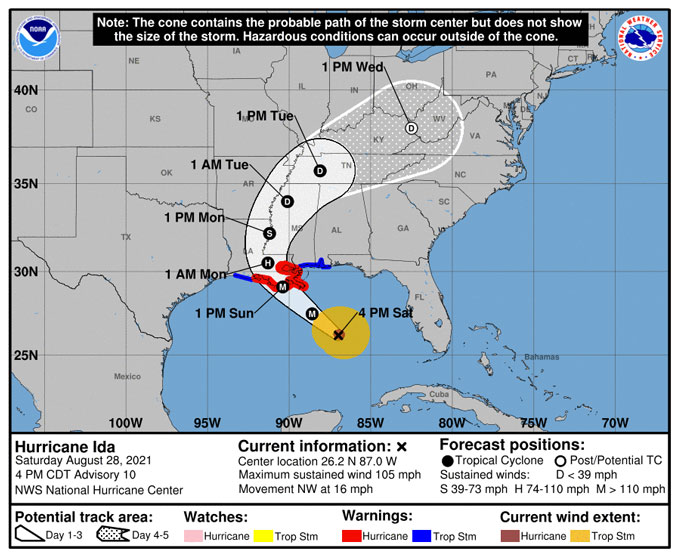
Rapidly strengthening Hurricane Ida is forecast to become the first landfall hurricane on United States soil in 2021, and is forecast to be a very dangerous Category 4 major hurricane with impacts across the Gulf Coast and Southeast. At 4:00 p.m. CDT Saturday, Hurricane was strengthening rapidly over the Gulf of Mexico about 240 miles SSE of the mouth of the Mississippi River. Hurricane Ida was recorded with Maximum Sustained Winds of 105 MPH and was moving NW at 16 MPH with a centra pressure of 976 MB or 28.82 in. Hg.
Evacuations were underway Saturday across parts of the Gulf Coast as officials around the region urged residents to make final preparations for the hurricane landfall on Sunday. The eye of the Major Hurricane is forecast to arrive at the Louisiana coast by 1:00 p.m. Sunday, August 2, 2021, with damaging winds arriving before 8:00 a.m. Hurricane Ida is forecast to be a Category 4 Hurricane as early as 4:00 a.m. Sunday.
Here is the latest rainfall forecast for Hurricane #Ida. pic.twitter.com/4YDeBNp7s7
— National Hurricane Center (@NHC_Atlantic) August 28, 2021
Here is the latest peak storm surge forecast for the northern Gulf Coast from Hurricane #Ida pic.twitter.com/UGsQIxmEIS
— National Hurricane Center (@NHC_Atlantic) August 28, 2021
A Hurricane Warning was issued for New Orleans and nearby communities at 4:16 p.m. Saturday. Winds will begin picking up by 6:00 a.m. Sunday and gusts of 45 MPH and higher will begin by 9:00 a.m. Peak gusts over 60 MPH are forecast for about 6:00 p.m. Over 16 inches of rain could fall between 7:00 a.m. Sunday and noon on Monday.
There is a danger of life-threatening storm surge inundation Sunday along the coasts of Louisiana, Mississippi, and Alabama within the Storm Surge Warning area. Extremely life-threatening inundation of 9 feet or greater above ground level is possible somewhere within the area from Morgan City, Louisiana, to the coast of Mississippi. Overtopping of local levees outside of the Hurricane and the Storm Damage Risk Reduction System is possible where local inundation values may be higher. Interests throughout the warning area were warned that they should follow any advice given by local officials.
Ida is expected to be an extremely dangerous major hurricane when it reaches the coast of Louisiana. Hurricane-force winds are expected Sunday in portions of the Hurricane Warning area along the Louisiana coast, including metropolitan New Orleans, with potentially catastrophic wind damage possible where the core of Ida moves onshore. Actions to protect life and property should be rushed to completion in the warning area.
Damaging winds near the track of the center of Ida across portions of southeastern Louisiana and southwestern Mississippi Sunday night and early Monday. These winds will likely lead to widespread tree damage and power outages. The greatest impacts of a northward-moving hurricane are likely near the eye and on the tropical cyclone’s northern and eastern side.
As a Tropical Depression, the remnant system of Hurricane Ida is forecast turn heading northeast and barely touch Illinois. Instead Tennessee, Kentucky, far southern Indiana, southern Ohio and West Virginia will be in the path of the tropical depression system Tuesday through Wednesday.
Hurricane Katrina, was a Category 3 storm when it struck Louisiana 16 years ago on August 29, 2005. Hurricane Katrina had reached a Category 5 level over the warm waters of the Gulf of Mexico, and after making landfall at Hallandale Beach, Florida on August 25, 2005.
Here is the current view of #HurricaneIda churning over the Gulf of Mexico, courtesy of the #GOESEast 🛰️.
Get the latest on #Ida: https://t.co/arzjJiHnjF pic.twitter.com/v4ExyaVAcx
— NOAA Satellites (@NOAASatellites) August 28, 2021
This composite imagery is called a "sandwich" loop, and it is made by combining visible and infrared satellite imagery channels. The resulting multi-dimensional image gives meteorologists and researchers additional insight into severe weather, such as #Hurricane #Ida, below. pic.twitter.com/ojOE5xaKKe
— NOAA Satellites (@NOAASatellites) August 28, 2021
Live Coverage Hurricane Ida approaches Louisiana from CBS affiliate WWL-TV. YouTube Tips ⓘ

Get updates from The Cardinal ALL NEWS FEEDS on Facebook. Just ‘LIKE’ the ‘Arlington Cardinal Page (become a fan of our page). The updates cover all posts and sub-category posts from The Cardinal — Arlingtoncardinal.com. You can also limit feeds to specific categories. See all of The Cardinal Facebook fan pages at Arlingtoncardinal.com/about/facebook …
Help fund The Cardinal Arlingtoncardinal.com/sponsor
OVER THE GULF OF MEXICO – @NOAA WP-3D Orion #NOAA43 Miss Piggy flying through the eyewall of Hurricane #Ida the morning of 08.28.21. Credit: Lt. Cmdr. Doremus, NOAA Corps.
NOAA event page for Ida – https://t.co/JRMe4KQZfE
Follow @NHC_Atlantic + local WFO for forecast#FlyNOAA pic.twitter.com/MInuLab9IW— NOAA Aircraft Operations Center (@NOAA_HurrHunter) August 28, 2021
OVER THE GULF OF MEXICO – Views from this morning's flight on @NOAA WP-3D Orion #NOAA43 Miss Piggy into the eye of Hurricane #Ida. Credit: Lt. Cmdr. Doremus, NOAA Corps.
Follow @NHC_Atlantic and your local @NWS Weather Forecast Office for forecasts and advisories.#FlyNOAA pic.twitter.com/188J81haqM— NOAA Aircraft Operations Center (@NOAA_HurrHunter) August 28, 2021
OVER THE CARIBBEAN – NOAA WP-3D Orion #NOAA42 mascot and turbulence indicator "Kermit" enjoys the sunset during a calm period while tracking Hurricane #Ida on 08.27.21. Credit: Lt. Cmdr. Shaw, NOAA Corps.
Follow @NHC_Atlantic for latest forecast and advisories#FlyNOAA #sunset pic.twitter.com/rPEWH6k764— NOAA Aircraft Operations Center (@NOAA_HurrHunter) August 28, 2021
