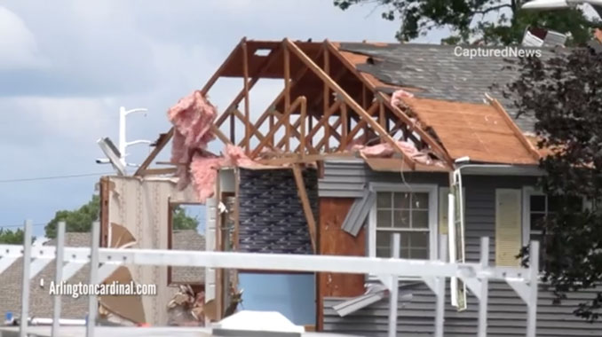
Day after Sunday night destructive tornado in Naperville on Monday, June 21, 2021. YouTube Tips ⓘ
According to the National Weather Service Chicago office, during the late evening into early overnight of Sunday, June 20, storms increased in intensity rapidly as they moved toward and into the Chicago metropolitan area, with damaging winds and tornadoes.
The most significant storm damage occurred in the southwest suburbs of Naperville, Woodridge, Darien, Burr Ridge, and Willow Springs between 11:00 and 11:30 pm, where a preliminary EF-3 tornado tracked through the area. The tornado damage survey for this tornado has not yet been completed, with additional details likely determined on June 22. Peak winds may have reached 140 MPH in Naperville, Woodridge, and Darien.
The EF-3 tornado caused damage to about 130 residences, utility poles, and many trees.
No fatalities were reported. There were at least eight injuries in Naperville that resulted in individuals being transported to hospitals, according to the National Weather Service. One person was initially listed in critical condition. There were many other minor injuries that were treated on scene. One woman on 77th Street near Werhli Road in Naperville received a scratch on her face from a flying branch inside her home. Winds pushed through a sliding glass door and also “rearranged” her furniture inside her home.
Sunday night’s tornado in Naperville, Woodridge and Darien is the first significant tornado (rating of EF-2 or greater) to occur in the NWS Chicago County Warning Area since February 28, 2017 (Naplate/Ottawa) and the first EF-2+ tornado to occur in the Chicago metro counties since June 22, 2015 (Coal City). A list of EF-2+ tornadoes in the Chicago metro can be found here. This is accessible on our tornado climatology for the area here.
Also on Sunday, and EF-0 tornado with peak winds of 85 mph and path length of 3.2 miles touched down in Plainfield and lifted in Romeoville. Tree damage was common along the path of the tornado.
There were also other areas of rotation and some with damage occurring, and these weather areas of rotation may also have been tornadoes. One radar image showed a severe squall line capable of producing both tornadoes and extensive straight line wind damage located over Wood Dale or Elk Grove Village caused the activation of a Tornado Warning which was tweeted by the National Weather Service at 10:46 PM. Most of these looked much more brief, although in far northwest Indiana there was sustained rotation from near Hobart to South Haven and eastward.
The first Tornado warning in Chicagoland Sunday night, which included the west side of Naperville, was tweeted by the National Weather Service at 10:43 PM.
Tornado Warning including Aurora IL, Saint Charles IL, West Chicago IL until 11:15 PM CDT pic.twitter.com/3uY2iCKhzu
— NWS Tornado (@NWStornado) June 21, 2021
Tornado Warning including Evanston IL, Skokie IL, Des Plaines IL until 11:30 PM CDT pic.twitter.com/JV6p6NznL6
— NWS Tornado (@NWStornado) June 21, 2021
^^ MOBILE? USE VOICE MIC ^^
facebook …
Please ‘LIKE’ the ‘Arlington Cardinal Page. See all of The Cardinal Facebook fan pages at Arlingtoncardinal.com/about/facebook …
Help fund The Cardinal Arlingtoncardinal.com/sponsor
20240105-1435future
THANKS FOR READING CARDINAL NEWS


 Amazon Best Sellers in Audible Books