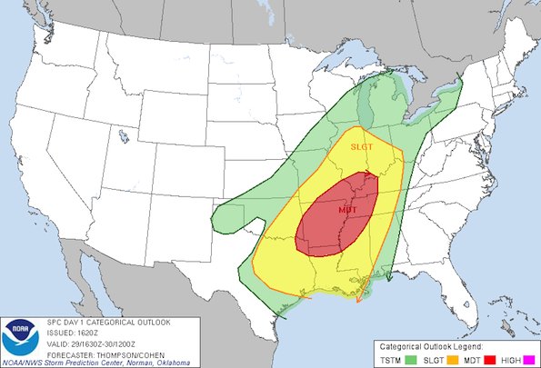
Severe weather outlook issued at 10:20 a.m. CST (See also spc.noaa.gov/products/outlook).
The NOAA Storm Prediction Center at 10:00 a.m. has placed a slight risk of severe thunderstorms and at least a 2% risk of a tornado for most of Illinois. At least a 5% risk of a tornado has been placed over the southern half of the state. The southern tip of Illinois has at least a 10% risk of a tornado. Earlier this morning the northern Chicago suburbs were included in the 2% zone for risk of a tornado, but the zone was contracted about 10:00 a.m. CST.
While the overall risk zone contracted away from the north suburbs, the higher risk area of severe weather has been expanded and now includes almost all of Arkansas, far southern Illinois, western Kentucky, western Tennessee, northwest Mississippi, and northern Louisiana.
Generally this type of outlook is reliably correlated with a future confirmed tornado or multiple tornados somewhere in the risk areas. The greatest severe risk is expected this evening and tonight.
Thunderstorms are still likely in the north and northwest suburbs, and a Flood Watch is in effect. It is not unlikely that a Severe Thunderstorm Warning could be issued in northern Chicagoland with the greatest chance for storms and heavy rain between 6:00 p.m. and midnight Tuesday. Rainfall amounts of 1-2 inches are possible in the northwest suburbs from about 11:00 a.m. until 3:00 p.m. Wednesday.
Air Temperatures at about 9:50 a.m.
Arlington Heights … 61°F
Atlanta … 62°F (10:52 ET)
Baton Rouge … 73°F
Champaign … 59°F
Metropolis … 64°F
Nashville … 61°F
St. Louis … 68°F
Chicago’s temperature of 59°F at 6:00 a.m. CT tied the all-time weather record for January 29. Chicago Executive Airport reported 60°F at 6:00 a.m.
Become a fan of The Cardinal weather page. Submit your pictures or just stay up-to-date on weather topics — go direct to the Arlington Cardinal Weather photos. For a list of all of The Cardinal Facebook fan pages, go to Arlingtoncardinal.com/about/facebook …
