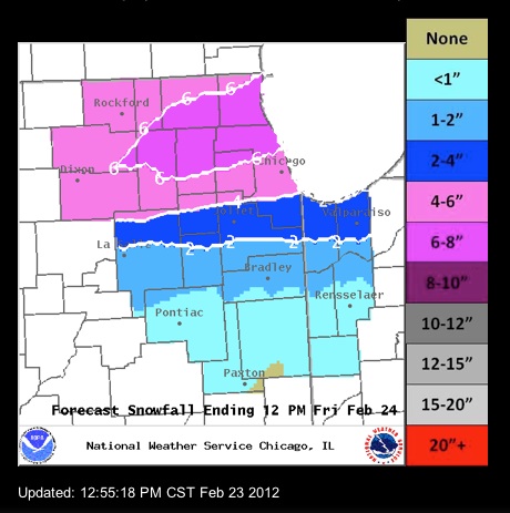
With the precipitation of the present winter storm system already beginning, the precipitation has been mainly rain across the area. Temperatures are above freezing, and snow might not begin until about 6:00 p.m. That’s the good news for rush hour commuters.
The bad news is that the deepest snowfall fall is directly on the northwest suburbs of northwest Cook County and the northern third of Cook County; and including the northern two-thirds of Kane County, the southern half of McHenry County and more than three-fourths of southern Lake County. Thundersnow is still possible with embedded thunderstorm during snowfall.
A Winter Storm Warning could still be activated later today or this evening. The area of heaviest snow could still shift south toward Interstate 88. The timing of freezing temperatures and heavy precipitation is still a factor. One thing is certain: The snow will be heavy and wet “Heart Attack Snow.”
Rain and some big snow flakes are falling at 1:52 p.m. Thursday.
NWS conditions at Chicago Executive Airport
Lat: 42.11 Lon: -87.9 Elev: 646
Last Update on Feb 23, 12:52 pm CST
Light Rain
39 °F
(4 °C)
Humidity: 82 %
Wind Speed: SE 8 MPH
Barometer: 29.53″ (1000.4 mb)
Dewpoint: 34 °F (1 °C)
Wind Chill: 33 °F (1 °C)
Visibility: 5.00 mi
Become a fan of The Cardinal weather page. Submit your pictures or just stay up-to-date on weather topics — go direct to the Arlington Cardinal Weather photos. For a list of all of The Cardinal Facebook fan pages, go to Arlingtoncardinal.com/about/facebook …

