A rare November tornado touches down in Oklahoma, and is captured by Basehunters weather chase team based out of Norman, Oklahoma.
Severe thunderstorms with a tornado outbreak were captured by videographers near the Blue Canyon Wind Farm northwest of Lawton, Oklahoma and northeast of the Wichita Mountains Wildlife Refuge.
Amazing video from the Basehunters weather chase team captured several tornado scenes. Once scene shows the tornado passing right through the Blue Canyon Wind Farm with little turbine blade movement observed. No report of damage to the windmills. At one point a Basehunter team member says something not heard very often during a tornado chase: A request to turn on the car window defroster.
No injuries were reported, but firefighters rescued people from flood homes in Murray County, about 75 miles east of Lawton, Oklahoma.
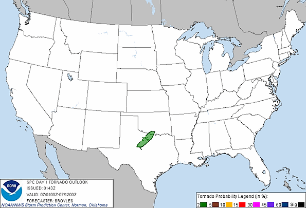
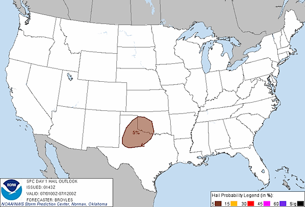
Convective Outlook Graphics for 11-07-2011 below …

Probabilistic tornado graphic for November 7, 2011.

Probabilistic large hail graphic for November 7, 2011.
Southern Plains notice on November 7, 2011 …
…SRN PLAINS…
A LINE OF DEVELOPING THUNDERSTORMS IS CURRENTLY ONGOING ACROSS NORTH
TX ALONG THE NWRN EDGE OF MODERATE INSTABILITY. FORECAST SOUNDINGS
IN NORTH TX EARLY THIS EVENING SHOW SFC-BASED CAPE OF 1500
J/KG…40-45 KT OF 0-6 KM SHEAR AND VEERING WINDS WITH HEIGHTS FROM
THE SFC TO 700 MB. THIS ENVIRONMENT MAY SUPPORT AN ISOLATED
SUPERCELL THREAT WITH A MARGINAL TORNADO POTENTIAL. HAVE ADDED A 2
PERCENT TORNADO PROBABILITY FROM NEAR ABILENE NEWD INTO FAR SRN OK
FOR THIS EVENING. AS A VIGOROUS UPPER-LEVEL TROUGH MOVES INTO THE
DESERT SOUTHWEST…LOW-LEVEL FLOW WILL STRENGTHEN ACROSS THE SRN
PLAINS RAPIDLY INCREASING MOISTURE ACROSS WEST TX LATE TONIGHT. IN
SPITE OF A BOUNDARY LAYER INVERSION…MODEL FORECASTS INITIATE
SCATTERED THUNDERSTORMS FROM LUBBOCK AND AMARILLO ENEWD INTO WRN OK
EARLY THIS MORNING ALONG THE AXIS OF A 30 TO 45 KT LOW-LEVEL JET.
FORECAST SOUNDINGS IN THIS CORRIDOR AT 09Z TO 12Z SHOW STEEP LAPSE
RATES FROM 700 TO 500 MB…60 KT OF CLOUD LAYER SHEAR AND MUCAPE OF
1500 J/KG. THIS ENVIRONMENT SHOULD SUPPORT SUPERCELLS WITH ISOLATED
LARGE HAIL AS STORMS INITIATE AROUND 09Z AND RAPIDLY INCREASE TOWARD
DAYBREAK. HAVE MAINTAINED A 5 PERCENT HAIL PROBABILITY FOR THIS
SCENARIO.
See also …
http://www.facebook.com/basehunters

Thanks for using our video! Just a couple of factual corrections. The SPC graphic here is actually valid only until 6AM on 11/7, as it was the 01:00 UTC forecast. The correct graphic is here: http://www.spc.noaa.gov/products/outlook/archive/2011/day1otlk_20111107_1200.html. SPC did expect significant tornadoes on 11/7.
The other comment, we use the defroster quite often on chases. Not because of icing, but because windows fog up near storms because of abrupt temperature and humidity changes.
Isaac, Thanks for the comment and corrections. I had a feeling The Cardinal would get called out on the defroster statement. Great video.