
Humidity is high in the low levels near the surface tonight, and with high pressure forecast to move overhead, there is potential for fog.
No rain likely overnight Monday to Tuesday morning, but additional rounds of thunderstorms are probable Tuesday through Friday. Any organized storm clusters through Wednesday night to early Thursday could bring a threat of damaging winds and/or flooding.
Very warm and humid conditions are likely Tuesday through Thursday, but magnitude of the heat potential will depend on storm timing and coverage which remains uncertain at Monday night’s point of view.
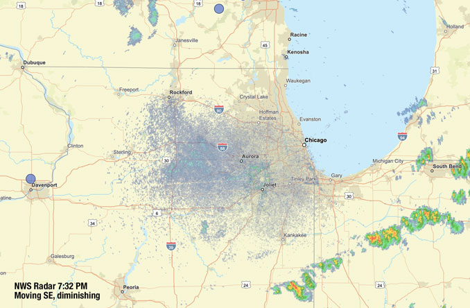
Weather Radar in northeast Illinois was clear at 7:30 p.m.
See also Arlingtoncardinal.com/clouds

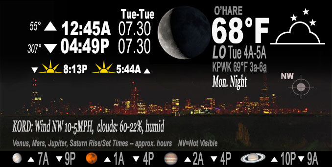
O’HARE FORECAST …
Monday Night: A 20 percent chance of showers before 10pm. Partly cloudy, with a low around 68. West northwest wind around 5 mph.
Tuesday: Mostly sunny, with a high near 91. West northwest wind 5 to 10 mph.
Tuesday Night: A 50 percent chance of showers and thunderstorms, mainly after 1am. Mostly cloudy, with a low around 73. South wind 5 to 10 mph.
Wednesday: A 40 percent chance of showers and thunderstorms. Partly sunny, with a high near 90. Heat index values as high as 99. South southwest wind 5 to 10 mph.
Wednesday Night: A 50 percent chance of showers and thunderstorms. Partly cloudy, with a low around 74. South wind 5 to 10 mph.
Thursday: A 30 percent chance of showers and thunderstorms. Partly sunny, with a high near 89.
Thursday Night: A 50 percent chance of showers and thunderstorms. Partly cloudy, with a low around 71.
Friday: A chance of showers and thunderstorms. Partly sunny, with a high near 83.
Friday Night: Partly cloudy, with a low around 70.
Saturday: Sunny, with a high near 86.
Saturday Night: Mostly clear, with a low around 69.
Sunday: Sunny, with a high near 85.
Sunday Night: Mostly clear, with a low around 67.
Monday: Sunny, with a high near 86.
LAKE TEMPS …
SOUTHERN LAKE MICHIGAN WATER TEMPERATURES
NATIONAL WEATHER SERVICE CHICAGO/ROMEOVILLE IL
1008 AM CDT Mon Jul 29 2024
LAKE MICHIGAN WATER TEMPERATURES…
CHICAGO SHORE………..75.
CHICAGO CRIB…………70.
CHICAGO BUOY…………75.
WILMETTE BUOY………..74.
WAUKEGAN BUOY………..74.
WINTHROP HARBOR BUOY….70.
MICHIGAN CITY………..67.
MICHIGAN CITY BUOY……75.
SOUTH MID LAKE BUOY…..74.
CENTRAL MID LAKE BUOY…71.
NORTH MID LAKE BUOY…..69.
&&
july.chicagoweatherstation.com
Chicago Weather Forecast for your MAC/PC/TABLET includes surrounding suburbs.
^^ MOBILE? USE VOICE MIC ^^
facebook …
Please ‘LIKE’ the ‘Arlington Cardinal Page. See all of The Cardinal Facebook fan pages at Arlingtoncardinal.com/about/facebook …
Help fund The Cardinal Arlingtoncardinal.com/sponsor
Area Forecast Discussion
National Weather Service
Chicago/Romeoville, IL
701 PM CDT Mon Jul 29 2024
.KEY MESSAGES…
– Additional rounds of thunderstorms probable Tuesday through Friday. Any organized storm clusters through Wednesday night/early Thursday could bring a threat of damaging winds and/or flooding.
– At least very warm and humid conditions likely Tuesday through Thursday, but magnitude of the heat potential will depend on storm timing and coverage which remains uncertain.
&&
.DISCUSSION… Issued at 310 PM CDT Mon Jul 29 2024
Through Tuesday:
Remnant shower activity across Lake County and northern Cook County is being driven by the mesoscale convective vortex left over from the morning convection. Instability along and north of I-80, closer to the larger scale forcing, is muted given limited solar insolation today with leftover low to mid level cloud shield.
Aloft, we can visualize on 3D water vapor loops the back edge of mid level vorticity advection already advancing through northeast Illinois and some drying in the lower to mid levels which will act to limit deeper convection. At the surface, there is a subtle boundary noted around I-55 with a wind shift to west and some lower dewpoints upstream, but ahead of it, an uncapped though only modestly unstable airmass exists. As the front advances, we do expect at least some scattered convection. Effective shear will be limited to around 25 kt, and thus widespread organized thunderstorms are not likely, however with moist low levels and some drying aloft, an elevated DCAPE axis will spread into the area south/east of I-55 may promote a few cells capable of gusty winds. The window of time is through 6pm-7pm before the main forcing gets cut off. PWAT values will pool( moisture convergence) along this corridor extending from the lake southward. With PWATs pushing 1.9″, storms will produce heavy rain, but storm motions of 30 mph should limit training.
It will be somewhat moist in the low levels tonight, mostly near the surface, and with high pressure progged to move overhead, there would be fog potential. However, the rain footprint has not been widespread this afternoon, and thus guidance is not hitting it too hard. Best chances would be outside the metro.
The front will get shoved a bit farther north on Tuesday as low level jet strengthens again across the plains in response to additional fast moving shortwave activity across the upper Midwest. The morning will start off warm and humid with the bulk of forcing will focused well to the west. Cloud cover will also be thin enough to preclude temperatures marching on through the 80s and dewpoints will also surge back into the lower 70s for most areas. Heat indices will make a run at 100 especially across the corn belt regions to the south/west. Attention will shift to the series of waves that will transit the ridge and then head southeastward toward the area on Tuesday and Tuesday night. Guidance is mixed to the eastern extent of impacts from the first wave Tuesday afternoon, and have therefore kept PoPs highest along and southwest along the highest instability axis. More on the severe threat from these waves in the long term discussion.
— KMD/NWS Chicago
Tuesday Night through Monday:
Our area will remain in a northwest mid and upper level flow pattern on the northern periphery of strong ridging from the southern Plains to the deep South into Thursday morning. A large MUCAPE reservoir will remain in place, lending to a likelihood of additional thunderstorm clusters over the general region as (convectively modulated) impulses interact with the instability reservoir.
Assuming the Tuesday daytime cluster does remain primarily southwest of the CWA, the next potential “window” of activity looks to be overnight Tuesday night into early Wednesday. Largely discounting the model solutions (such as the 12z GFS) with a stronger, slower, and farther north MCV igniting convection Tuesday evening over northern IL that would then track southeast. Current expectation is for generally quiet conditions to continue through the early to mid evening hours.
Additional low amplitude impulses paired with strengthening warm air advection (WAA), low-level moisture moisture advection, and associated isentropic ascent from these look to be the driving forces for potential uptick in convective coverage late Tuesday night. A majority (but not all) of the 12z HREF CAM (convective allowing models) keyed on this. Interestingly enough, there were recent model depictions, including the 12z ECMWF and NSSL-WRF-ARW, that had overnight development, but appreciably farther southwest.
Given the guidance variability and inherent uncertainty in these patterns, show PoPs coming up to high chance (~50%) overnight. If convection does develop, effective bulk shear of 30-40 kt and high PWAT air mass point toward a threat for damaging wind gusts and flash flooding. Scenario looks ripe for training and/or backbuilding storms in parts of the area, which would up the ante with the flash flooding threat. Confidence is low-medium in occurrence in the CWA and low regarding locations due to the range in plausible outcomes.
Conceptually speaking, organized convection into Wednesday morning could then mute the chances for additional storms for most of the rest of the day, so PoPs were capped at lower chance (~30%) in the afternoon. Coverage in the morning, or lack thereof, and placement of effective boundaries, can then be expected to modulate the heat and humidity side of the equation Wednesday afternoon. We`re currently advertising a roughly middle ground forecast for temps, with highs in the upper 80s to around 90F and 70s dew points for upper 90s to mid 100s peak heat indices. May need a Heat Advisory for some counties, though again, confidence is low.
There has been a somewhat more coherent signal for a vigorous short-wave tracking across the area Wednesday night into early Thursday. This may yield a strong to severe MCS in the region, and an attendant flash flooding threat from training and/or backbuilding convection. It`s still way too early to realistically pin down details further than this, however. Similar to Wednesday, the extent of any Thursday afternoon convection in the wake of overnight/early-mid AM activity is quite unclear (30-40% PoPs). The forecast temps and peak heat indices are also similar to/slightly lower in spots than on Wednesday.
For the Thursday night-Friday afternoon period, guidance has trended toward a closed mid-upper low drifting over the area, which will probably be a somewhat messy period with additional waves of showers and scattered storms. It will be cooler (highs lower to locally mid 80s) but still humid on Friday, with onshore flow developing north of the surface low reflection. After this feature exits southeast Friday night, this should set up a largely quieter weekend, along with a bit of a break in the humidity and warm but likely not hot temps (coolest shore due to onshore winds).
— Castro/NWS