
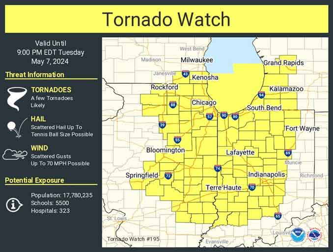
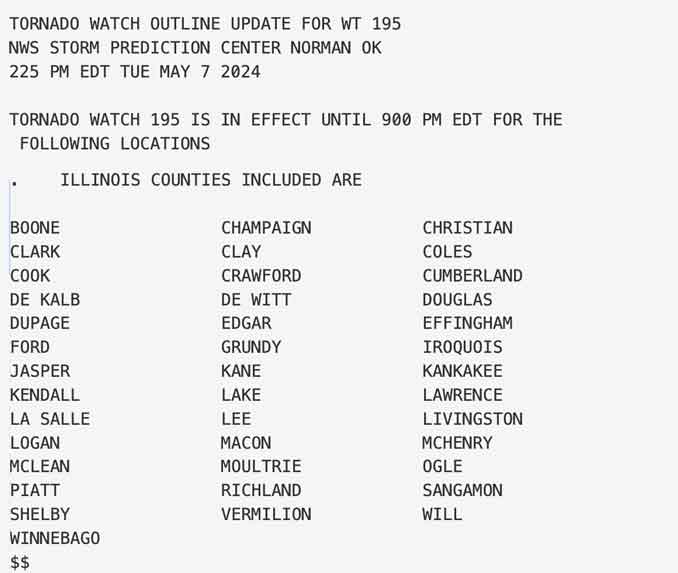
A Tornado Watch for the Chicago metro area, almost half of Illinois, and more than half of Indiana was issued by the National Weather Service at 1:25 PM. The first Tornado Warnings in the Chicago metro area were in Boone County and McHenry County beginning about 2:12 p.m.
Tornado Watch in effect from May 7, 01:25 PM CDT until May 7, 08:00 PM CDT.
A second round of scattered thunderstorms is likely this afternoon, with the highest confidence east and southeast of the I-55 corridor. A few of these afternoon storms could become severe with large hail and damaging winds as the primary hazards.
A third round of storms may develop late Wednesday, some ofwhich could be strong to severe, mainly south of I-80 into central Illinois and Indiana.
The National Weather Service Office Chicago is closely monitoring conditions for an increased severe weather threat within the Chicago metro area through the mid- to late- afternoon. The area of greatest concern is across northwest Indiana where there is a more distinct tornado threat. The threat for damaging hail has also increased further northwest in the CWA, encompassing much of if not the entire Chicago metro area. Our window of severe weather potential is approximately from 1-5PM CDT.
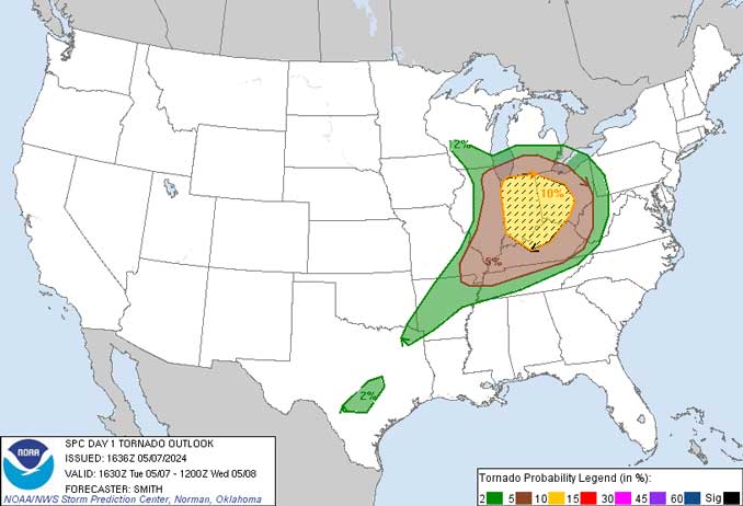
Arlington Heights and the northwest suburbs are in a tornado risk area with a forecasted 5% risk of tornado within 25 miles. The area population at risk is 21,639,609.
According to the NWS Storm Prediction Center, there is considerable uncertainty for this forecast due largely due to an ongoing broken squall line moving east across KY/IN/Lake Michigan, and the related influences for airmass destabilization (weakening) in its wake. However, clearing skies in the Mesoscale Convective system (thunderstorm complex) wake could result in a sufficient period of heating during the afternoon to cause more severe storms.
There has been on and off again sunshine today, and there has been more significant sunshine since around 1:40 p.m. in Arlington Heights with air temperatures in the upper 70s. See also Arlingtoncardinal.com/clouds
Weather Radar shows strong thunderstorms especially south near Joliet, Illinois and near Rockford about 1:50 p.m. Tuesday, May 7, 2024. The storms are moving from southwest to northeast. Tornado Warnings were issued for Boone County, and McHenry County beginning about 2:12 p.m. Severe Thunderstorm Warnings have been activated in the southwest Chicago metro area.
A tornado watch has been issued for parts of Illinois, Indiana, Michigan and Wisconsin until 9 PM EDT pic.twitter.com/xWAXwfpgsp
— NWS Chicago (@NWSChicago) May 7, 2024
O’HARE FORECAST …
Tuesday Afternoon: Showers and thunderstorms likely, mainly before 5pm. Partly sunny, with a high near 75. Southwest wind around 15 mph, with gusts as high as 25 mph. Chance of precipitation is 60%. New rainfall amounts between a tenth and quarter of an inch, except higher amounts possible in thunderstorms.
Tuesday Night: Isolated showers and thunderstorms before 1am. Mostly clear, with a low around 55. West southwest wind around 10 mph, with gusts as high as 20 mph. Chance of precipitation is 20%.
Wednesday: A 30 percent chance of showers and thunderstorms after 1pm. Mostly sunny, with a high near 77. Southwest wind 5 to 10 mph becoming east southeast in the afternoon.
Wednesday Night: Showers likely and possibly a thunderstorm. Mostly cloudy, with a low around 52. Northeast wind 10 to 15 mph, with gusts as high as 20 mph. Chance of precipitation is 70%.
Thursday: Showers likely and possibly a thunderstorm. Mostly cloudy, with a high near 57. Breezy, with a north wind 15 to 20 mph, with gusts as high as 30 mph. Chance of precipitation is 60%.
Thursday Night: Partly cloudy, with a low around 45.
Friday: Mostly sunny, with a high near 64.
Friday Night: A chance of showers after 1am. Partly cloudy, with a low around 50.
Saturday: A chance of showers, then showers likely and possibly a thunderstorm after 1pm. Partly sunny, with a high near 64.
Saturday Night: Partly cloudy, with a low around 48.
Sunday: Mostly sunny, with a high near 69.
Sunday Night: Partly cloudy, with a low around 52.
Monday: Mostly sunny, with a high near 75.
Chicago Weather Forecast for your MAC/PC/TABLET includes surrounding suburbs.
^^ MOBILE? USE VOICE MIC ^^
facebook …
Please ‘LIKE’ the ‘Arlington Cardinal Page. See all of The Cardinal Facebook fan pages at Arlingtoncardinal.com/about/facebook …
Help fund The Cardinal Arlingtoncardinal.com/sponsor