
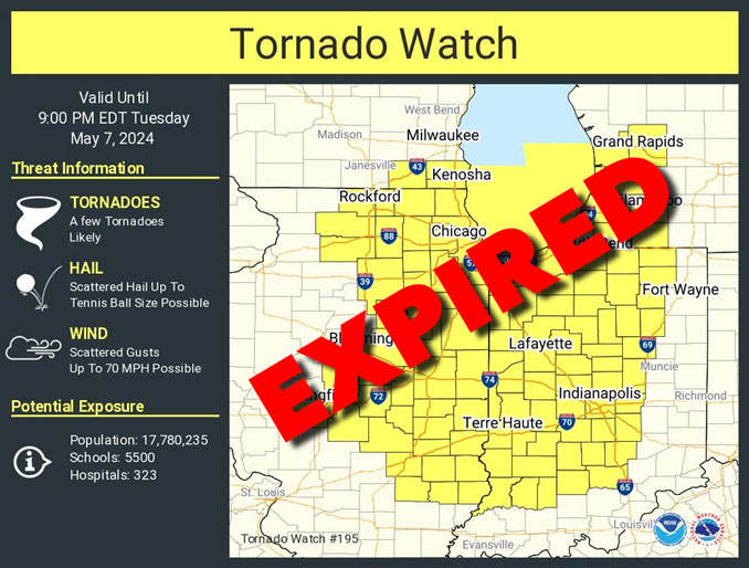
The threat for any additional severe thunderstorms has ended by 5-6 p.m. CDT for the Chicago metro area. The Tornado Watch initially issued until 8:00 p.m. CDT and all Tornado Warnings have expired in the Chicago metro area have expired, but some Tornado Warnings were active at 5:15 p.m. CDT in Indiana and Michigan.
During severe weather in the 200 p.m. hour, a large barn collapsed with animals trapped inside and a tree fell on a power line at the same farm property in the block of 10800 Weidner Road of Harvard, Illinois in McHenry County where there was a Tornado Warning.
Weather Radar shows storms only in an area between Davenport and Burlington, Iowa, and is completely clear in northeast Illinois at 5:10 p.m. There were storms over Lake Michigan moving to the northeast at 5:10 p.m. with Special Marine Warnings in effect.
See also Arlingtoncardinal.com/clouds
Severe storms brought strong winds, rain and hail to parts of Illinois, Indiana and Wisconsin on Tuesday afternoon, leaving behind some damage.
Amid the severe storms, a barn in Harvard, Illinois, collapsed while animals were inside.https://t.co/t0L5kKAU6q— WGN TV News (@WGNNews) May 7, 2024
Severe storms left a barn completely flattened in Harvard, IL, on Tuesday as crews rush to inspect the damage.
FOX Weather meteorologist @SteveBenderWx has the latest. #ILwx pic.twitter.com/jX63xpMduB
— FOX Weather (@foxweather) May 7, 2024
A scene of complete destruction where a barn collapsed at 10810 Weidner Road, north of Harvard. Multiple fire agencies are assisting with the rescue of animals trapped in the collapse. Neighbors are helping & bringing in heavy equipment. More at https://t.co/vhbRxCcLib pic.twitter.com/3IMoOEsL1P
— Kris Habermehl (@KrisHabermehl) May 7, 2024
Another round of thunderstorms may develop late Wednesday into Wednesday night, some of which could be strong to severe,
mainly south of I-80 into central Illinois and Indiana.
Cooler weather with periodic showers Thursday and then Friday night into the weekend are forecast.
The temperature reached a high of around 75-77°F in Chicago metro on Tuesday with a low of around 57°F forecast over night with partly cloudy to mostly clear skies and winds around 8 to 9 MPH. The satellite view shows a good amount of clearing over northern Illinois.
Loyola Medicine Allergy Count for 5-7-2024
Trees – High- Primary: Mulberry
Grass – High
Ragweed – Absent
Weeds – Absent
Mold – Moderate
https://twitter.com/LoyolaAllergy/status/1787852642288378305
O’HARE FORECAST …
Early Tuesday Evening: A 20 percent chance of showers and thunderstorms. Partly sunny, with a high near 75. Southwest wind around 15 mph, with gusts as high as 25 mph.
Tuesday: Mostly clear, with a low around 57. West southwest wind around 10 mph, with gusts as high as 20 mph.
Wednesday: A 20 percent chance of showers after 4pm. Mostly sunny, with a high near 79. Southwest wind 5 to 10 mph becoming east southeast in the afternoon.
Wednesday Night: A chance of showers and thunderstorms, then showers likely and possibly a thunderstorm after 10pm. Mostly cloudy, with a low around 51. Northeast wind 10 to 15 mph, with gusts as high as 20 mph. Chance of precipitation is 70%.
Thursday: Showers likely and possibly a thunderstorm. Mostly cloudy, with a high near 56. Breezy, with a north wind 15 to 20 mph, with gusts as high as 30 mph. Chance of precipitation is 60%.
Thursday Night: Partly cloudy, with a low around 45.
Friday: Mostly sunny, with a high near 63.
Friday Night: A chance of showers. Partly cloudy, with a low around 50.
Saturday: A chance of showers after 1pm. Mostly sunny, with a high near 65.
Saturday Night: Partly cloudy, with a low around 48.
Sunday: Mostly sunny, with a high near 72.
Sunday Night: Partly cloudy, with a low around 55.
Monday: Mostly sunny, with a high near 75.
Monday Night: Partly cloudy, with a low around 56.
Tuesday: A chance of showers. Sunny, with a high near 77.
LAKE TEMPS …
SOUTHERN LAKE MICHIGAN WATER TEMPERATURES
NATIONAL WEATHER SERVICE CHICAGO/ROMEOVILLE IL
937 AM CDT Tue May 7 2024
LAKE MICHIGAN WATER TEMPERATURES…
CHICAGO SHORE………..58.
CHICAGO CRIB…………56.
WINTHROP HARBOR BUOY….53.
MICHIGAN CITY………..M.
&&
M IS FOR MISSING DATA THAT IS NORMALLY AVAILABLE.
THE MICHIGAN CITY WATER TEMPERATURE SENSOR IS LOCATED AT
A WATER INTAKE ONE MILE OFFSHORE AND 60 FEET BELOW THE
WATER SURFACE. IT IS READ EVERY DAY OF THE YEAR.
Chicago Weather Forecast for your MAC/PC/TABLET includes surrounding suburbs.
^^ MOBILE? USE VOICE MIC ^^
facebook …
Please ‘LIKE’ the ‘Arlington Cardinal Page. See all of The Cardinal Facebook fan pages at Arlingtoncardinal.com/about/facebook …
Help fund The Cardinal Arlingtoncardinal.com/sponsor
Area Forecast Discussion
National Weather Service Chicago/Romeoville, IL
407 PM CDT Tue May 7 2024
.KEY MESSAGES…
– Threat for any additional severe thunderstorms ending by 5-6 PM CDT today
– Another round of thunderstorms may develop late Wednesday into Wednesday night, some of which could be strong to severe, mainly south of I-80 into central Illinois and Indiana
– Cooler with periodic showers Thursday and then Friday night into the weekend
&&
.MESOSCALE… Issued at 407 PM CDT Tue May 7 2024
Surface trough/confluence zone continues to move eastward across extreme eastern IL. Storms developing along this boundary continue to struggle, likely a result of weak low level convergence and a very dry mid-upper level air mass. Air mass ahead of this boundary remains unstable and uncapped based on RAP mesoanalysis and confirmed by blossoming Cu field on visible satellite imagery. Winds are slightly more backed across northwest Indiana, so convergence may be a bit stronger as the boundary gets into northwest Indiana, so it is still possible we could see a ramp upward in the intensity of some of these storms over the next couple of hours.
IND and IWX WSR-88D VWPs both show strong deep and low level shear which will continue to be supportive supercells, even where surface winds are slightly west of due south. Until the boundary clears our CWA, we will need to continue to closely monitor storms for any signs of sustained intensification and growth. Hail and damaging winds would be the main threats if any storms can grow sufficiently and become sustained. However, hodograph derived from latest IND VWP shows sufficient low level shear for a tornado threat given the low LCLs and strong low level CAPE.
– Izzi/NWS Chicago
&&
.DISCUSSION… Issued at 338 PM CDT Tue May 7 2024
Tonight through Wednesday Evening:
A post cold frontal short-wave may touch off a few showers and thunderstorms across portions of far northern Illinois through the early to mid evening, with slight chance (~15-20%) PoPs for this activity. Generally quiet weather is then expected tonight into Wednesday morning, as the mid-level short wave lifts northeast of the area and short wave mid-level ridging develops overhead. Winds will become light to calm tonight as weak surface high pressure slides across the area. Forecast lows tonight are in the mid to upper 50s, locally lower 50s.
The most recent guidance has trended drier through much of Wednesday afternoon, enabling another warm day (mid 70s to lower 80s F) despite increasing cloud cover. The exception to the warmth once to the early afternoon will be lakeshore areas due to winds turning onshore synoptically and aided by lake influence.
From late Wednesday afternoon through Wednesday night, another round of showers and thunderstorms is expected to develop. Some scattered showers may develop across far northern Illinois and across the state line into Wisconsin in the late afternoon. More notably, the approach of the next short-wave will result in a gradual uptick in showers and thunderstorms to the south of I-80 prior to sunset, and then spreading northward in the evening and overnight.
A surface low pressure wave is expected to develop along the cold/stationary front which will trail across the southern Plains in association with this wave, which will then propagate northeast into the mid-Mississippi Valley by Wednesday evening. Overall, the guidance has come into better agreement in barely returning the front northward into our far southern CWA (south of US-24) as a warm front by Wednesday evening. This is where some potential may exist for surface based severe weather threats, primarily damaging winds and hail.
Otherwise, as most of our area will be on the cool side of the front, the main concern will be elevated hail producing thunderstorms , some of which may become marginally severe (hail up to 1″ diameter) as mid-level lapse rates steepen amidst supportive effective bulk shear. In addition, seasonably high PWATs may present a localized ponding or even flooding threat, primarily near and south of I-80.
Castro/Ratzer/NWS Chicago
Late Wednesday Night through Tuesday:
A mid-level trough extending southwest across Quebec and southern Ontario will phase with a mid-level low over the Missouri Valley late Wednesday night. As the phasing wave crosses the area on Thursday, a residual low to mid-level TROWAL combined with PWATs around 1″ and a deep layer favoring warm rain processes supports the potential for a low-end localized band of heavy rain (1-2″ totals by mid day Thursday) across portions of northern Illinois into southern Wisconsin. Outside of this band, scattered diurnally enhanced showers and perhaps a few storms are expected. Much cooler conditions are in store, with highs only in the upper 50s to lower 60s inland and lower to mid 50s near Lake Michigan. Adding to the cool feel, northerly winds will gust up to 25-35 mph, strongest near the lake.
After a quick-moving ridge yields dry and seasonable temps on Friday, another upper-level low is progged to cross the western Great Lakes on Saturday. Anomalously cold mid-level temps shifting across the area through the day will yield scattered showers and storms, with some stronger cores likely producing locally strong wind gusts. Diverging solutions by early next week with regards to handling of the departure of Saturday`s upper low and a building ridge to the west greatly diminishes the forecast by early next week. It appears temperatures will trend back to above normal by the end of the period.
Kluber/Castro/NWS Chicago
&&
.AVIATION /18Z TAFS THROUGH 00Z THURSDAY/… Issued at 1259 PM CDT Tue May 7 2024
Key Aviation Messages:
– Scattered TSRA, possibly locally severe this afternoon – SE winds shifting SW and gusting over 20 knots around 19Z
Satellite analysis depicts MVFR clouds growing in depth to become more concerning for thunderstorm expansion across NE Illinois in the 18z-19z hour and then expanding into NW Indiana after 19z or so. The storms in around Chicago and points westward do pose a threat for hail along with winds in excess of 35 kt. The main window for storms will continue until about 23-0z, longest in NW Indiana, with the main window for the Chicago terminals through 2230z.
VFR conditions will return behind the storms this evening, with initially breezy SW winds easing overnight. Winds will shift southeasterly and then easterly through the late morning into the afternoon Wednesday. Another batch of precipitation will shift toward NE Illinois later in the day. Confidence in thunder toward the tail end of the 30 hr TAF is still below 30 percent.
KMD/NWS Chicago