
Weather forecast for O’Hare International Airport, Tuesday, April 9, 2024 (CARDINAL NEWS). YouTube Tips ⓘ
A weak cold front will continue moving across the area early this morning, but impacts are expected to be minimal. The National Weather Service Office for Chicago indicates a strong signal for unseasonably warm weather this weekend into early next week.
Forecast for rain beginning late Wednesday night or after midnight Wednesday/Thursday. Over one inch of rain possible Thursday, April 11, 2024.
Weather Radar shows precipitation in central and southern Illinois.
See also Arlingtoncardinal.com/clouds
A period of inclement weather will begin late Wednesday afternoon through Thursday night. There is also an increasing threat for heavy rain Wednesday night into Thursday which could lead to instances of river rises and localized flooding. #ILwx #INwx pic.twitter.com/ta2F5GteK9
— NWS Chicago (@NWSChicago) April 9, 2024
Loyola Medicine Allergy Count for 4-9-2024
Trees – Moderate
Grass – Low
Ragweed – Absent
Weeds – Absent
Mold – Low— Loyola Medicine Allergy Count (@LoyolaAllergy) April 9, 2024
Loyola Medicine Allergy Count for 4-9-2024
Trees – Moderate
Grass – Low
Ragweed – Absent
Weeds – Absent
Mold – Low
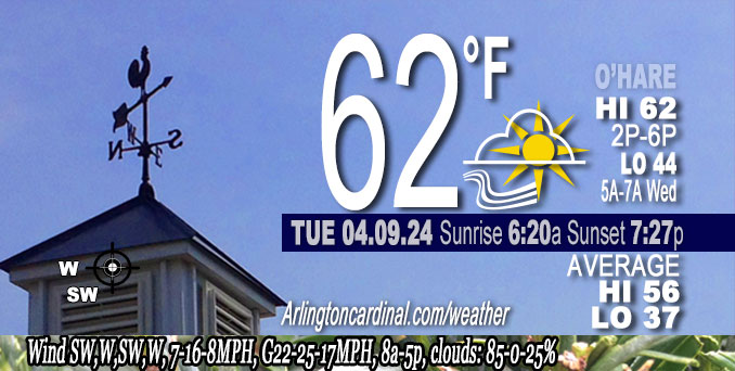
O’HARE FORECAST …
Tuesday: Mostly sunny with a high of 62. Southwest and west winds 7 mph to 16 mph, gusting to 25 mph.
Tuesday Night: Mostly clear, with a low around 44. Southwest wind around 5 mph.
Wednesday: Increasing clouds, with a high near 67. South wind 5 to 10 mph becoming east in the afternoon.
Wednesday Night: Rain, mainly after 1am. Low around 47. North northeast wind around 10 mph, with gusts as high as 15 mph. Chance of precipitation is 80%. New precipitation amounts between a quarter and half of an inch possible.
Thursday: Rain. High near 51. Breezy, with a north northeast wind 15 to 20 mph, with gusts as high as 30 mph. Chance of precipitation is 90%.
Thursday Night: Rain likely, mainly before 1am. Mostly cloudy, with a low around 46. Breezy, with a west northwest wind around 20 mph, with gusts as high as 35 mph. Chance of precipitation is 70%.
Friday: A 20 percent chance of rain before 1pm. Partly sunny, with a high near 58. Breezy.
Friday Night: Mostly clear, with a low around 43. Breezy.
Saturday: Sunny, with a high near 68.
Saturday Night: Partly cloudy, with a low around 55.
Sunday: Mostly sunny, with a high near 75.
Sunday Night: Partly cloudy, with a low around 50.
Monday: Mostly sunny, with a high near 66.
Monday Night: A chance of showers. Partly cloudy, with a low around 50.
Tuesday: A chance of showers. Partly sunny, with a high near 68.
LAKE TEMPS …
SOUTHERN LAKE MICHIGAN WATER TEMPERATURES
NATIONAL WEATHER SERVICE CHICAGO/ROMEOVILLE IL
912 AM CDT Tue Apr 9 2024
LAKE MICHIGAN WATER TEMPERATURES…
CHICAGO SHORE………..45.
CHICAGO CRIB…………45.
MICHIGAN CITY………..45.
SOUTH MID LAKE BUOY…..41.
&&
M IS FOR MISSING DATA THAT IS NORMALLY AVAILABLE.
THE MICHIGAN CITY WATER TEMPERATURE SENSOR IS LOCATED AT A WATER INTAKE ONE MILE OFFSHORE AND 60 FEET BELOW THE WATER SURFACE. IT IS READ EVERY DAY OF THE YEAR.
april.chicagoweatherstation.com
Chicago Weather Forecast for your MAC/PC/TABLET includes surrounding suburbs.
^^ MOBILE? USE VOICE MIC ^^
facebook …
Please ‘LIKE’ the ‘Arlington Cardinal Page. See all of The Cardinal Facebook fan pages at Arlingtoncardinal.com/about/facebook …
Help fund The Cardinal Arlingtoncardinal.com/sponsor
Area Forecast Discussion…CORRECTED
National Weather Service Chicago/Romeoville, IL
628 AM CDT Tue Apr 9 2024
.KEY MESSAGES…
– A large rain system will impact portions of the Midwest late Wednesday and Thursday bringing the potential for elevated rain totals to the area. Lots of uncertainty in place with this storm.
– Strong signal for unseasonably warm weather this weekend into early next week
&&
.DISCUSSION… Issued at 3:32 AM CDT Tue Apr 9 2024
Through Wednesday:
Weak cold front will continue moving across the area early this morning, but impacts are expected to be minimal. Air mass in the wake of the front is only a bit colder than antecedent air mass. So while it will be cooler than yesterday, high temps today are still expected to be mild. High cloudiness is expected today, especially southern CWA, but still anticipate some mixed sunshine.
Moisture streaming north well in advance of the approaching southern plains cyclone is expected to begin encroaching on the area Wednesday. First in the form of cloudiness, but eventually rain could develop later in the day south of I-80. There remains considerable spread in available guidance regarding timing and track of this system, with ECMWF among the fastest/farthest northwest, thus quickest to spread rain this far north. This is a sizable adjustment from earlier runs, so did increase pops, but only in a measured manner given the still large spread in guidance.
– Izzi/NWS Chicago